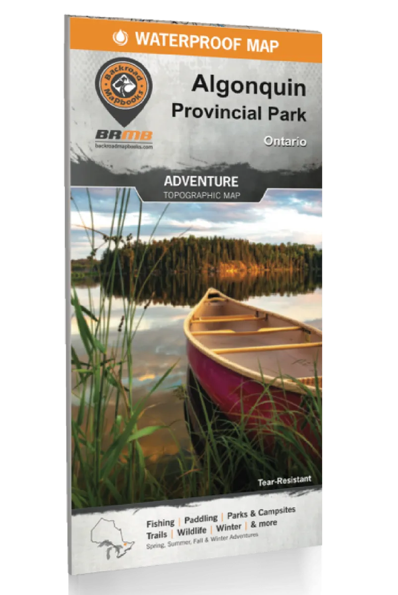
Cooking Essentials&Outdoor Tools|Foldable Shovels,Windproof Stoves&Headlamps
Cooking Essentials&Outdoor Tools|Foldable Shovels,Windproof Stoves&Headlamps Cooking Essentials&Outdoor Tools|Foldable Shovels,Windproof Stoves&Headlamps
Home Navigation Gear Waterproof Hiking Map
Backroad Mapbooks Algonquin Map - Waterproof

Backroad Mapbooks Algonquin Map - Waterproof

$ 19.95

$ 0.00

Save: $

Unavailable
Please select combo product attributes
The combo subtotal is $,SAVE$

Product Details

  • Description
  • Features
  • Specifications

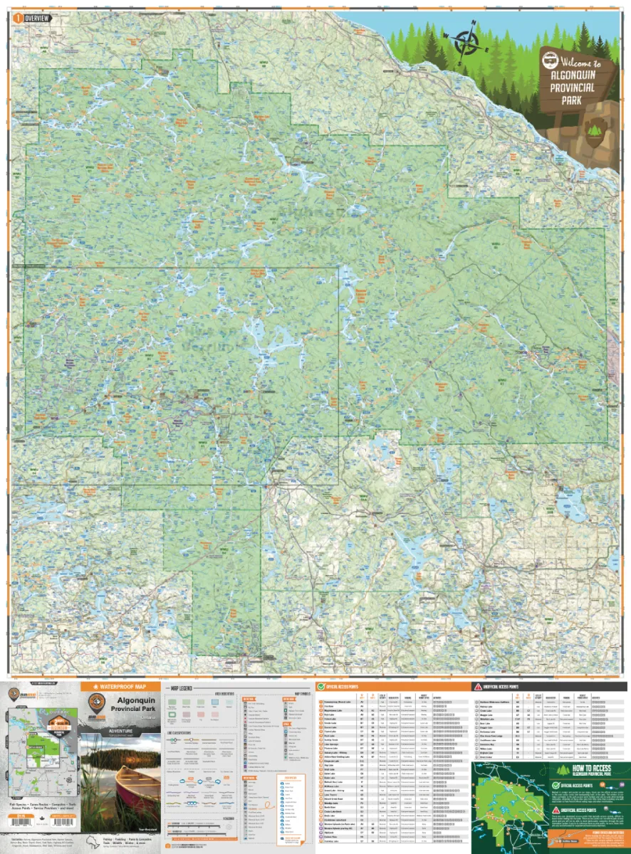
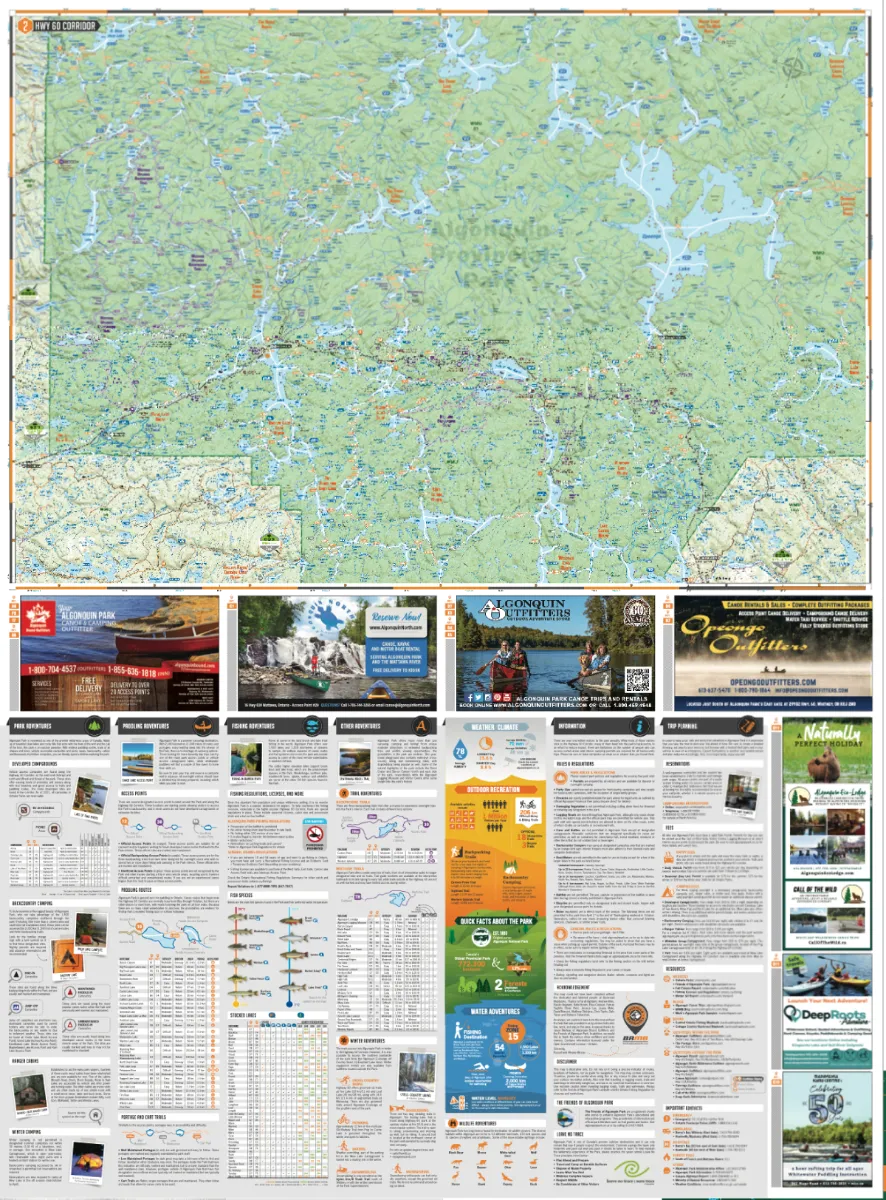
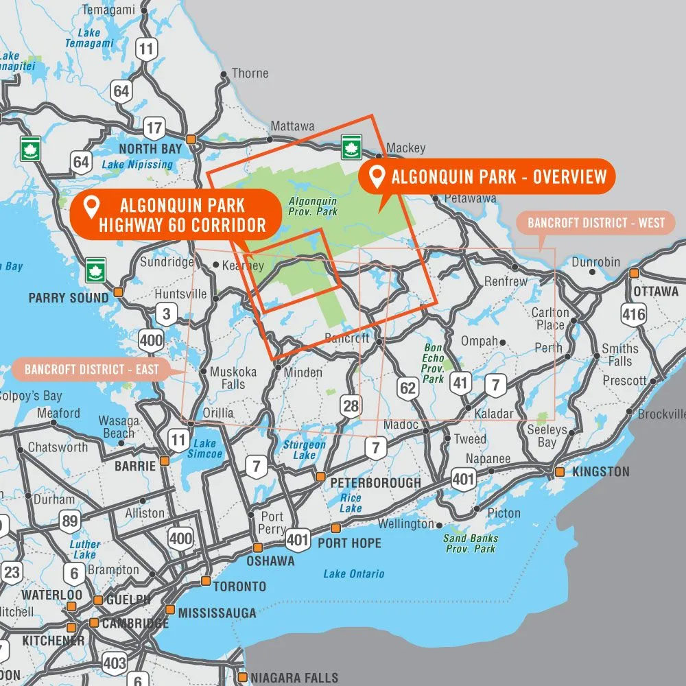
  • Spanning an area of 7,653 km2 (2,955 mi2), Algonquin Provincial Park is one of Canada's largest and most popular provincial parks. Visitors to this Ontario park will quickly understand the popularity of sprawling forests of red and white pine surrounding an endless patchwork of pristine lakes (around 2,400 in total) that are perfect for paddling. A secluded, water-access campsite is always just around the corner and several fantastic hikes lead deep into the scenic forests. Waterproof and designed to withstand the elements (it even floats) this two-in-one park map includes an unparalleled level of detail and covers the entire park area on one side and the Highway 60 Corridor on the other side.

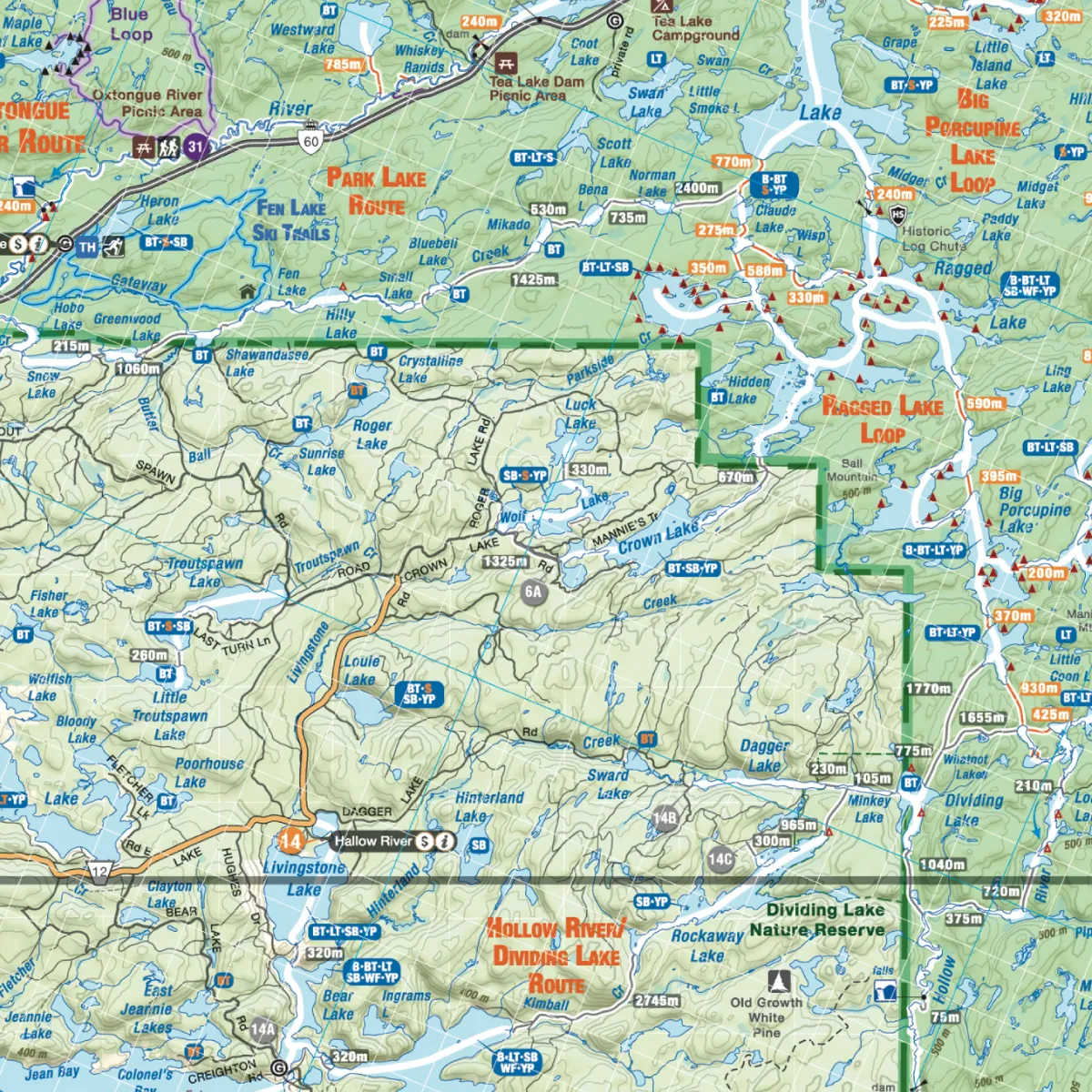
    Providing everything in one place to help you enjoy your Algonquin Provincial Park adventures, the maps chart out all the park's canoe routes, with access points, front and backcountry campsites, unique attractions, portages, trails, and more. Anglers looking for the best locations to fish Algonquin Park will love the fact that the lakes and rivers are labelled with sportfish species and lake stocking information. Whether you are planning a day trip to the park or a multi-day adventure, this recently updated and reviewed map gives you the most comprehensive coverage available for one of Canada's most popular parks!

          • Double-sided waterproof map
          • Easy-to-read maps derived from the Backroad Mapbooks at 1:140,000 and 1:75,000 scale
          • Dual-sided 86 x 117 cm (34 x 46.25 in) map offers unparalleled, close-up detail of the Highway 60 Corridor on one side and the entire provincial park on the other side.
          • Seamless map coverage requires no page-turning.
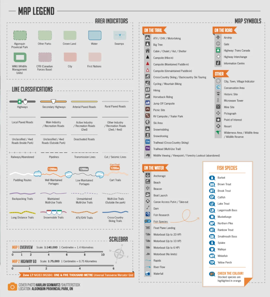
          • UTM grids with latitude and longitude make navigating the map easy.
          • Printed on durable waterproof and tear-resistant material: it even floats!
          • Close collaboration with park officials and local outfitters make this the most up-to-date and accurate map available for Algonquin Park
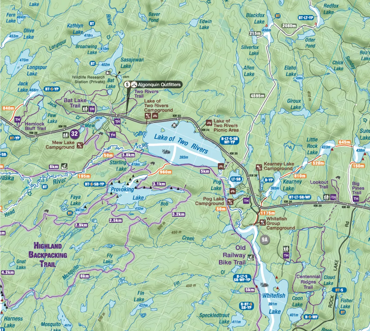
          • Countless points of interest, paddling routes, hiking trails, campsites, beaches, and more!
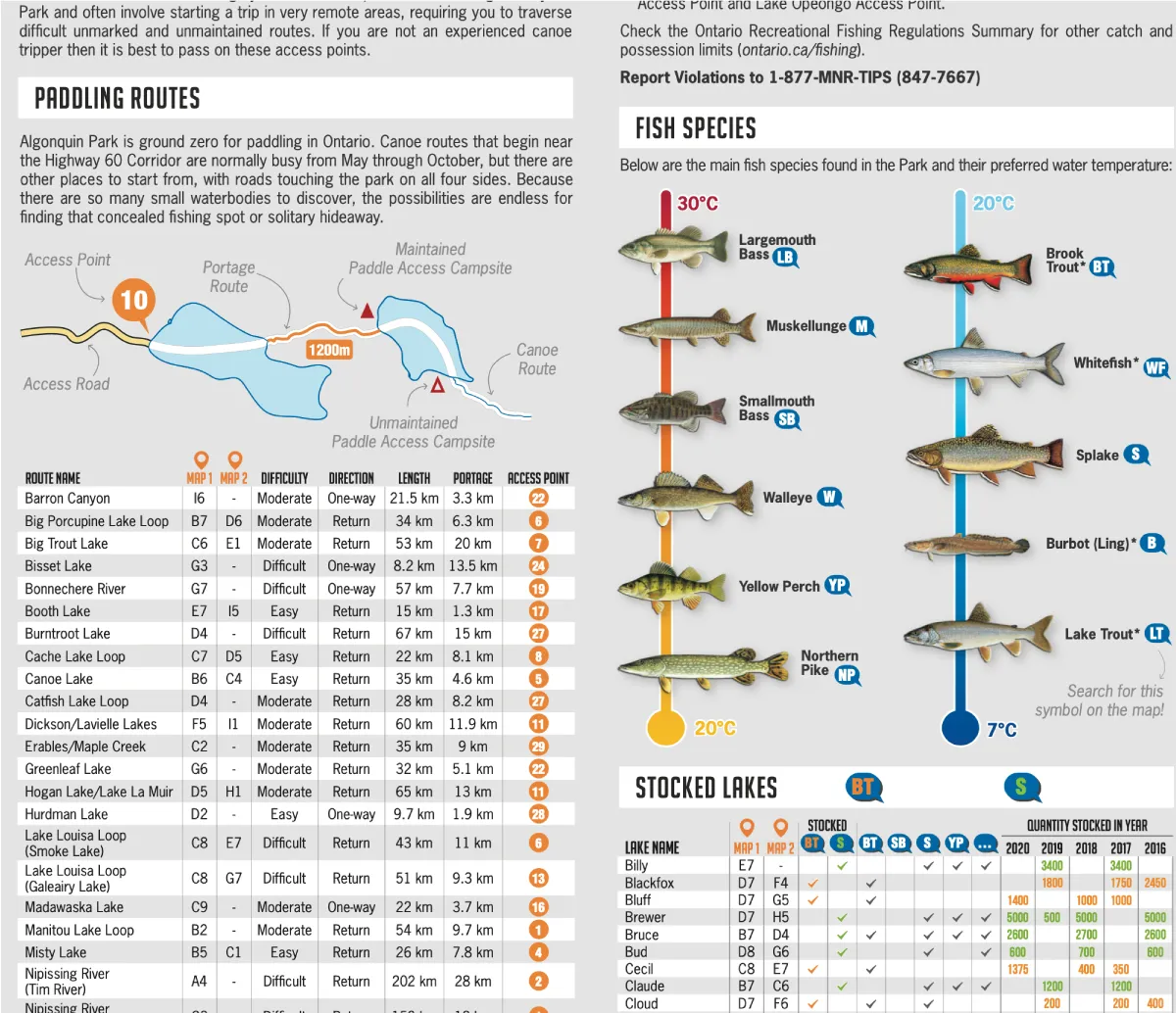
          • Anglers will find fish species listed for lakes and rivers, boat launch locations and trout stocking information.
          • Park planning tools including camping, detailed trail and paddling information, park regulations and contact details.
          • Paddling chart with dozens of canoe routes and paddle-in campsites
          • Portage trails labelled with distance and designated as low or high maintained
          • Comprehensive hiking, biking and ski trail coverage with distance and difficulty
          • Showcases the highways, logging, and access roads that are open to the public
          • Hundreds of land and water geographic features
          • List of all the best Algonquin outfitters
          • And much more!
          • Released: 2021
          • Pages: 2
          • Paper: Waterproof
          • Dimensions: 86 x 117 cm (34 x 46.25 inches)
          • Scale: Map 1 1:140,000 / Map 2 1:75,000
          • Map Features: Highways, Logging Roads, Land & Water Features, Parks, Adventure Points of Interest, Campgrounds, Hiking Trails, Motorized Trails, Paddling Routes, Hunting & Fishing Areas, Winter Recreation and More
          • Areas Covered: Achray, Algonquin Provincial Park, Barron Canyon, Barry's Bay, Basin Depot, Brent, East Gate, Highway 60 Corridor, Kingscote, Kiosk, Madawaska, West Gate, Whitney and more!

        You May Also Like

        Park Valley UT topo map, 1:62500 Scale, 15 X 15 Minute, Historical, 1959, Updated 1960, 20.8 x 17 in
        Park Valley UT topo map, 1:62500 Scale, 15 X 15 Minute, Historical, 1959, Updated 1960, 20.8 x 17 in

        $ 48.00

        $ 69.00

        Save: $

        Portable Camping Stove,Camping Cook Stove | Foldable Adjustable Flower Shield Stainless Cassette Burner Piezoelectric Ignition Windproof for Beach Outings Disaster
        Portable Camping Stove,Camping Cook Stove | Foldable Adjustable Flower Shield Stainless Cassette Burner Piezoelectric Ignition Windproof for Beach Outings Disaster

        $ 24.00

        $ 29.00

        Save: $

        BESPORTBLE Stainless Steel Gas Camping Stove Portable Foldable for Fire Pit Cooking
        BESPORTBLE Stainless Steel Gas Camping Stove Portable Foldable for Fire Pit Cooking

        $ 22.00

        $ 31.00

        Save: $

        YARNOW 1set Portable Outdoor Stove of Camping Gas Stove Burner for Hiking Trekking and Picnics Button for Easy Use
        YARNOW 1set Portable Outdoor Stove of Camping Gas Stove Burner for Hiking Trekking and Picnics Button for Easy Use

        $ 14.00

        $ 17.00

        Save: $

        Pennine Way 2 - Standedge to Ickornshaw - Zigzag map
        Pennine Way 2 - Standedge to Ickornshaw - Zigzag map

        $ 9.95

        Save: $

        Men Faux Leather Zip Up Jacket Stand Collar Leather Motorcycle Jacket Lightweight Bomber Outwear PU Coat
        Men Faux Leather Zip Up Jacket Stand Collar Leather Motorcycle Jacket Lightweight Bomber Outwear PU Coat

        $ 24.00

        $ 34.00

        Save: $

        Peaches Gingham Foldable Beach Canopy UPF50 Waterproof Outdoor Sun Shade with Sandbags & Sand Shovel for Camping, Picnics, Backyard
        Peaches Gingham Foldable Beach Canopy UPF50 Waterproof Outdoor Sun Shade with Sandbags & Sand Shovel for Camping, Picnics, Backyard

        $ 56.00

        $ 101.00

        Save: $

        baleaf Men's Rain Jacket Waterproof Windbreaker Running Cycling Golf Hiking Gear Hood Lightweight Reflective Packable
        baleaf Men's Rain Jacket Waterproof Windbreaker Running Cycling Golf Hiking Gear Hood Lightweight Reflective Packable

        $ 39.00

        $ 56.00

        Save: $

        Backroad Mapbooks Algonquin Map - Waterproof
        Backroad Mapbooks Algonquin Map - Waterproof

        $ 19.95

        Save: $

        LHKNL Headlamp Rechargeable, Lumen Super Bright Motion Sensor Head Lamp Flashlight, Waterproof LED Headlight with White Red Light, 8 Mode Head Lights for Camping Cycling Running Fishing-4 Packs
        LHKNL Headlamp Rechargeable, Lumen Super Bright Motion Sensor Head Lamp Flashlight, Waterproof LED Headlight with White Red Light, 8 Mode Head Lights for Camping Cycling Running Fishing-4 Packs

        $ 28.00

        $ 40.00

        Save: $

        Cart
        Cooking Essentials&Outdoor Tools|Foldable Shovels,Windproof Stoves&Headlamps
        Your cart is currently empty.