Cooking Essentials&Outdoor Tools|Foldable Shovels,Windproof Stoves&Headlamps
Cooking Essentials&Outdoor Tools|Foldable Shovels,Windproof Stoves&Headlamps Cooking Essentials&Outdoor Tools|Foldable Shovels,Windproof Stoves&Headlamps
Home Navigation Gear Waterproof Hiking Map
Naalehu HI topo map, 1:24000 Scale, 7.5 X 7.5 Minute, Historical, 1962, Updated 1964, 26.8 x 24 in

Naalehu HI topo map, 1:24000 Scale, 7.5 X 7.5 Minute, Historical, 1962, Updated 1964, 26.8 x 24 in

$ 45.00

$ 64.00

Save: $

Color:
  • Polypropylene
  • Regular Paper
  • Tyvek
Unavailable
Please select combo product attributes
The combo subtotal is $,SAVE$

Product Details

  • Printed on Polypropylene (plastic)
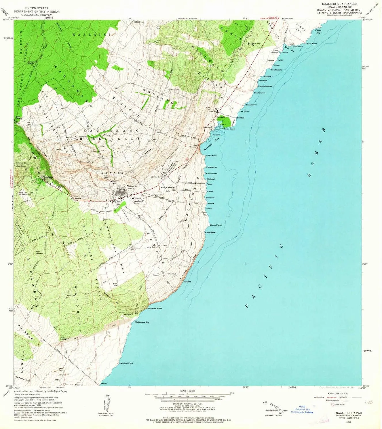
  • USGS topographic map of Naalehu, HI, at 1:24000 scale. Heavier material. Waterproof. Tear-resistant. Foldable. Perfect for the outdoors.
  • Cities, towns, villages: Waikapuna,Wai??hinu,Kipuka Nahuaopala (historical),Honu?apo,N???lehu,Napumaia (historical)
  • Islands: Kawelohea
  • Parks and forests: Wai??hinu Park,Whittington Park


USGS topographic map of Naalehu, Hawaii, dated 1962, updated 1964.

Includes geographic coordinates (latitude and longitude), lines of elevation, bodies of water, roads, and more. This topo quad is suitable for recreational, outdoor uses, office applications, or wall map framing.

Printed on-demand by YellowMaps on the print material of your choice.

Shipping rolled from Minneapolis, MN, United States.

Product Number: USGS-5644242
Map Size: 26.8 inches high x 24 inches wide
Map Scale: 1:24000
Map Type: POD USGS Topographic Map
Map Series: HTMC
Map Version: Historical
Cell ID: 31262
Scan ID: 349603
Imprint Year: 1964
Woodland Tint: Yes
Aerial Photo Year: 1954
Field Check Year: 1962
Datum: Old Hawaiian
Map Projection: Polyconic
Map published by United States Geological Survey
Map Language: English
Scanner Resolution: 600 dpi
Map Cell Name: Naalehu
Grid size: 7.5 X 7.5 Minute
Date on map: 1962
Geographical region: Hawaii, United States
Northern map edge Latitude: 19.125°
Southern map edge Latitude: 19°
Western map edge Longitude: -155.625°
Eastern map edge Longitude: -155.5°

Surrounding map sheets (copy & paste the Product No. in the search bar):
North: USGS-5644388,USGS-5644392,USGS-5644390,USGS-5644386,USGS-5644384
East: USGS-5644712,USGS-5644708,USGS-5644710
South:
West: USGS-5643752,USGS-5643754,USGS-5643758,USGS-5643756

You May Also Like

Inflatable Camping Tent for Comfort and Convenience, Easy 5-Minute Setup, Fits 4-6 People, Waterproof and Windproof, Beige

$ 235.00

$ 671.00

Save: $

Little Donkey Andy Men's Lightweight Softshell Vest Windproof Sleeveless Jacket for Travel Hiking Running Golf

$ 26.00

$ 36.00

Save: $

MSR Windburner Personal Stove System, 1.0 Ltr

$ 427.49

Save: $

CREATMO US Boys Girls Rain Coat Kids Reflective Cycling Jacket Waterproof Packable Children Windbreaker With Removable Hood

$ 27.00

$ 39.00

Save: $

Fort Peck Lake East MT topo map, 1:100000 Scale, 30 X 60 Minute, Historical, 1978, Updated 1978, 28.1 x 33 in

$ 52.00

$ 74.00

Save: $

Camp Chef Expedition Three-Burner Stove - Portable Camping Cook Stove for Outdoor Cooking - Comes with Fry Griddle - 14" Accessory Compatible - 608 Sq In Cooking Space

$ 99.00

$ 400.00

Save: $

Mammut Alugator Ride 3.0

$ 74.99

Save: $

Roaring Gap NC topo map, 1:24000 Scale, 7.5 X 7.5 Minute, Historical, 1997, Updated 2000, 26.8 x 21.9 in

$ 45.00

$ 64.00

Save: $

Life Jacket Light Fire Rescue Position Lights Water Activated Strobe Light for Man Overboard Survival Yellow

$ 13.00

$ 16.00

Save: $

24x36 World Classic Premier Wall Map Poster (Laminated)

$ 16.00

$ 19.00

Save: $

Cart
Cooking Essentials&Outdoor Tools|Foldable Shovels,Windproof Stoves&Headlamps
Your cart is currently empty.