Cooking Essentials&Outdoor Tools|Foldable Shovels,Windproof Stoves&Headlamps
Cooking Essentials&Outdoor Tools|Foldable Shovels,Windproof Stoves&Headlamps Cooking Essentials&Outdoor Tools|Foldable Shovels,Windproof Stoves&Headlamps
Home Navigation Gear Laminated Hiking Map
Lake Tahoe Wall Map by Franko

Lake Tahoe Wall Map by Franko

$ 69.95

$ 0.00

Save: $

Finish:
  • Paper
  • Laminated
  • Laminated with Hang Rails
  • Canvas
  • Canvas with Hang Rails
Unavailable
Please select combo product attributes
The combo subtotal is $,SAVE$

Product Details

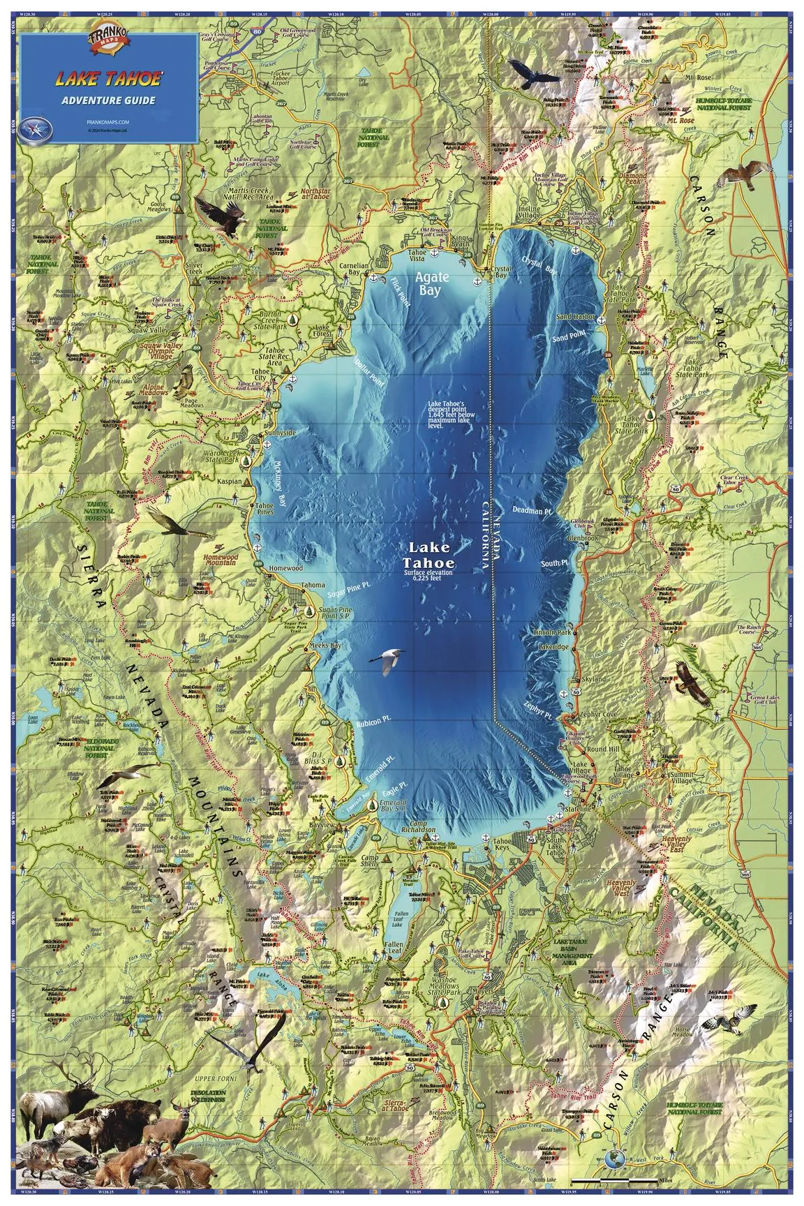
A gorgeous, detailed map of the lake and surrounding area, with land and water shading, extending at least 6 miles beyond the lake in each direction. The map shows town and place names, roads, the Tahoe Rim Trail and other hiking trails, national forests and recreation areas, ski areas, golf courses, mountain peaks, anchorages, and more.

The map can come either printed on heavyweight 160 gsm paper or laminated. The paper version is perfect for framing under glass, and the laminated version is exceptionally hard-wearing as we use a true encapsulation of two pieces of 80-micron gloss laminate.

Alternatively, we can supply this map on 395 gsm HP Professional Matte Canvas using pigment-based inks - making the map highly durable and fade resistant. The exceptional clarity of printing makes this map a stunning addition to any room, and its high quality means that it will provide years of enjoyment.

The easiest way to hang your canvas map is by having wooden hang rollers attached top and bottom with a hanging cord on the top roller, so all you have to do is put a hook on the wall. The hang rails come lacquered in a natural timber colour.

Note: Please allow ten working days to deliver the hang railed map as they need to be attached by our framer. 

Sizes:

  • 914(w) x 610 mm (h) 

You May Also Like

baleaf Men's Rain Jacket Waterproof Windbreaker Running Cycling Golf Hiking Gear Hood Lightweight Reflective Packable

$ 39.00

$ 56.00

Save: $

Arizona Recreation Wall Map Dry Erase Laminated Map – Wall Map, February 18, 2019

$ 28.00

$ 40.00

Save: $

Home Comforts Alpine Hut Rest House Hiking Tour Mountain Hut-20 Inch By 30 Inch Laminated Poster With Bright Colors And Vivid Imagery-Fits Perfectly In Many Attractive Frames

$ 13.00

$ 16.00

Save: $

High Power Rechargeable LED Headlamp - Waterproof Adjustable Head Flashlight, Hands-Free Head Torch for Camping, Hiking, Hunting, Fishing, Emergency, Outdoor Activities, Ultra Bright Comfortable Wear

$ 49.00

$ 70.00

Save: $

Ohiopyle / Laurel Highlands, Pennsylvania Map

$ 18.00

Save: $

Light Blue Gradient Foldable Beach Canopy UPF50 Water-Resistant Outdoor Sun Shade with Sandbags and Shovel for Family Trips, Picnics & Camping

$ 60.00

$ 110.00

Save: $

Sky Blue Foldable Beach Canopy UPF50 Waterproof Sun Shade with Sandbags and Shovel for Camping, Fishing, Backyard Fun

$ 60.00

$ 110.00

Save: $

TBMPOY Men's Hooded Softshell Jacket Waterproof Windproof Ski Hiking Outerwear Fleece Lined Winter Coat

$ 35.00

$ 50.00

Save: $

Stanton NE NE topo map, 1:24000 Scale, 7.5 X 7.5 Minute, Historical, 1963, Updated 1964, 26.8 x 22 in

$ 45.00

$ 64.00

Save: $

South Central United States Wall Map 1325 x 928mm

$ 99.95

Save: $

Cart
Cooking Essentials&Outdoor Tools|Foldable Shovels,Windproof Stoves&Headlamps
Your cart is currently empty.