Cooking Essentials&Outdoor Tools|Foldable Shovels,Windproof Stoves&Headlamps
Cooking Essentials&Outdoor Tools|Foldable Shovels,Windproof Stoves&Headlamps Cooking Essentials&Outdoor Tools|Foldable Shovels,Windproof Stoves&Headlamps
Home Navigation Gear Waterproof Hiking Map
East Hudson Trails Map - NYNJTC

East Hudson Trails Map - NYNJTC

$ 11.95

$ 0.00

Save: $

Unavailable
Please select combo product attributes
The combo subtotal is $,SAVE$

Product Details

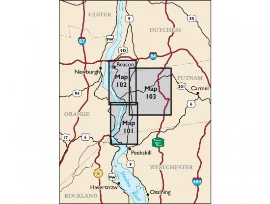
East Hudson Trails Map - 2018 - 12th edition

Three-map set, map #s 101, 102 & 103


Our East Hudson Trails Map is a three-map set featuring trails in the New York Highlands east of the Hudson River.  The maps are printed in vibrant color on waterproof and tear-resistant Tyvek, and are a must-have for enjoying the rich outdoor experiences throughout the Hudson Highlands region.  The 2018 update includes trail mileage numbers and enhanced contour lines, as well as several trail changes in places like Hudson Highlands State Park Preserve, Fahnestock State Park, and Manitou Point Preserve.

Map features include:

  • More than 150 miles of marked trails in portions of Dutchess, Putnam, and Westchester counties
  • Parklands including Clarence Fahnestock Memorial State Park, Hudson Highlands State Park Preserve, Castle Rock Unique Area, Hudson Highlands Gateway Park, Manitoga, Manitou Point Preserve, Mount Beacon Park, Nelsonville Nature Preserve, Watergrass Sanctuary, and West Point Foundry Preserve
  • More than 20 miles of the Appalachian Trail as it passes through Putnam County
  • The popular Breakneck Ridge destination
  • Junction-to-junction trail mileage numbers on the map front
  • 20-foot elevation contours
  • 1:31,683 scale (2 inches = 1 mile)
  • Convenient map sizes to carry and use on the trail
  • Parkland boundaries
  • Unmaintained trails and woods roads
  • Viewpoints, campsites, mines, and other points of interest
  • Parking areas
  • Public transportation
  • Park contact information, history, and regulations
  • UTM coordinate grid


Our East Hudson Trails Map is also available on Apple and Android mobile devices through the Avenza Maps app.

Trail Conference maps are built on more than 85 years of mapping experience.  They are the trusted source for reliable trail information in the New York-New Jersey metropolitan region.  These maps are "Made By the People Who Build the Trails" and are regularly updated with changes to the trails.

You May Also Like

THE NORTH FACE(ザノースフェイス) Shoulder Bag

$ 53.00

Save: $

33,000ft Men's Packable Rain Jacket Lightweight Rain Shell Jacket with Hood Waterproof Raincoat for Cycling

$ 40.00

Save: $

North Cape WI topo map, 1:24000 Scale, 7.5 X 7.5 Minute, Historical, 1959, Updated 1960, 27.26 x 21.76 in

$ 45.00

$ 64.00

Save: $

Bear Valley ID topo map, 1:125000 Scale, 30 X 30 Minute, Historical, 1893, Updated 1910, 18.8 x 15.7 in

$ 49.00

$ 82.00

Save: $

Nitecore Combo HC35 Rechargeable LED Headlamp - 2700 Lumen w/Eco-Sensa USB Charging Cable and TIP Keychain Light (Random Color)

$ 62.00

$ 112.00

Save: $

Dishpan, 9L Collapsible Washing Basin (Gray, PP, TPR), Portable Dish Tub with Drain Plug, Space-Saving Drying Rack for Kitchen, Camping, Laundry use

$ 18.00

$ 22.00

Save: $

E02 III (Black, Cool White Version, 6500K) 560 Lumens AAA/10440 Headlamp Pocket EDC Flashlight with Magnetic Tail & Reversible Clip

$ 21.00

$ 26.00

Save: $

Democratic Republic of the Congo Wall Map 914 x 1219mm

$ 69.95

Save: $

Burley WA topo map, 1:24000 Scale, 7.5 X 7.5 Minute, Historical, 1999, Updated 2003, 26.9 x 22 in

$ 31.00

$ 44.00

Save: $

Burbuja Pink Red Mushrooms Beach Canopy Windproof Beach Tent Sun Shade with 4 Sandbags & Sand Shovel, Portable Sun Shelter for Family Camping Picnic

$ 56.00

$ 102.00

Save: $

Cart
Cooking Essentials&Outdoor Tools|Foldable Shovels,Windproof Stoves&Headlamps
Your cart is currently empty.