- Printed on Tyvek® (synthetic)
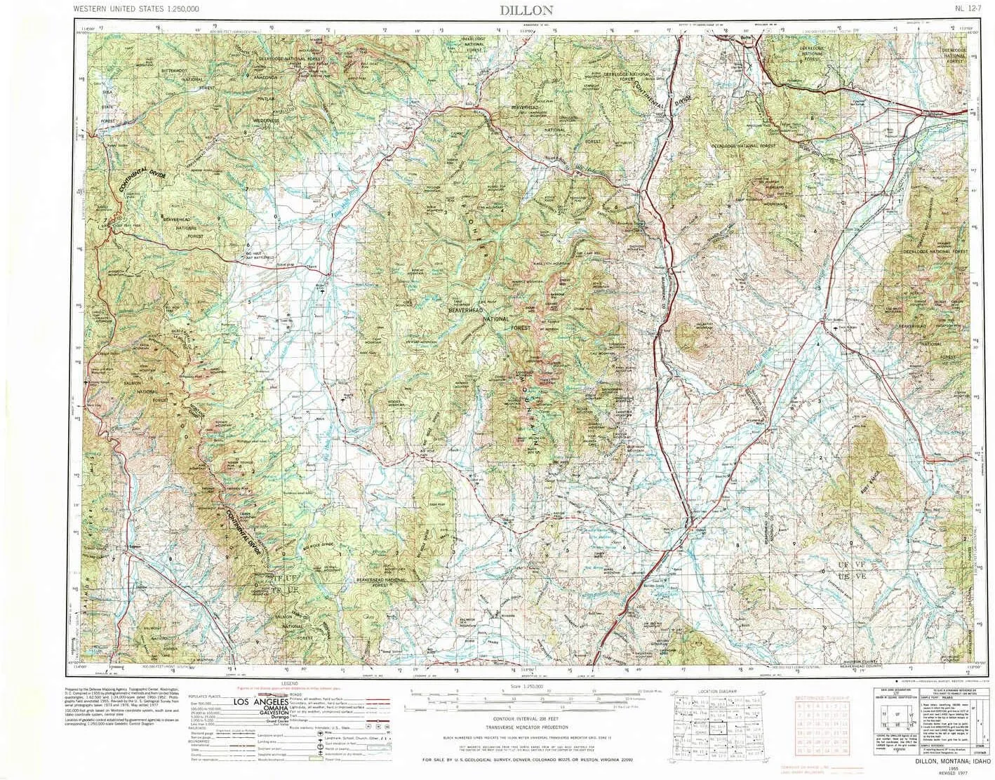
- USGS topographic map of Dillon, MT, at 1:250000 scale. Lighter material. Waterproof. Tear-resistant. Foldable. Very durable. Perfect for backpacking and the outdoors.
- Cities, towns, villages: Buxton,Butte-Silver Bow (balance),Patterson Corner,Dillon,Lion City (historical),Sciuchetti Place,Dewey,Woodin,Pipestone Hot Springs,Silver Star,Holden Place,Fairview (historical),Baker,French Gulch (historical),Nine-mile,Williamsburg,Waterloo,Melrose,Donald,East Bench (historical),Sweetwater (historical),Leary Place,Piedmont,Hale Place,Ermont Mill,Kingrey Place,Glen,Sheridan,Elkhorn Hot Springs,Delano Place,Elkhorn,Guntner Place,Wise River,Burdick Place,Grant
- Mountains: Pioneer Mountains,Anaconda Range,Highland Mountains,Rocky Hills,Sheep Mountain,Anderson Mountain,Lion Mountain,Lost Horse Mountain,Storm Peak,Monument Peak,Foolhen Mountain,Pandora Mountain,Bender Point,Manhead Mountain,Bell Peak,Baldy Mountain,West Pintler Peak
- Valleys: Vineyard Gulch,Cruiser Gulch,Jakes Draw,Whiskey Gulch,Big Bear Gulch,Box Canyon,Donegan Gulch,Wendel Canyon,Fox Gulch,Connor Gulch,Mountain View Gulch,Bridge Gulch,Long Gulch,Cyclone Gulch
USGS topographic map of Dillon, Montana, dated 1955, updated 1978.
Includes geographic coordinates (latitude and longitude), lines of elevation, bodies of water, roads, and more. This topo quad is suitable for recreational, outdoor uses, office applications, or wall map framing.
Printed on-demand by YellowMaps on the print material of your choice.
Shipping rolled from Minneapolis, MN, United States.
Product Number: USGS-5401946
Map Size: 22.1 inches high x 29.2 inches wide
Map Scale: 1:250000
Map Type: POD USGS Topographic Map
Map Series: HTMC
Map Version: Historical
Cell ID: 75025
Scan ID: 268700
Imprint Year: 1978
Woodland Tint: Yes
Aerial Photo Year: 1976
Edit Year: 1977
Datum: Unstated
Map Projection: Transverse Mercator
Map published by United States Geological Survey
Map Language: English
Scanner Resolution: 600 dpi
Map Cell Name: Dillon
Grid size: 1 X 2 Degree
Date on map: 1955
Geographical region: Montana, United States
Northern map edge Latitude: 46°
Southern map edge Latitude: 45°
Western map edge Longitude: -114°
Eastern map edge Longitude: -112°
Surrounding map sheets (copy & paste the Product No. in the search bar):
North: USGS-5401914,USGS-5401826,USGS-5401824,USGS-5401828,USGS-5390962
East: USGS-5401912,USGS-5401422,USGS-5618638,USGS-5401906,USGS-5400076
South: USGS-5437642,USGS-5437644,USGS-5437640,USGS-5437638,USGS-5437648
West: USGS-5437650,USGS-5437658,USGS-5436956,USGS-5437656,USGS-5437070
")


 (National Geographic Reference Map) Map – January 1, 2014")


")

