Cooking Essentials&Outdoor Tools|Foldable Shovels,Windproof Stoves&Headlamps
Cooking Essentials&Outdoor Tools|Foldable Shovels,Windproof Stoves&Headlamps Cooking Essentials&Outdoor Tools|Foldable Shovels,Windproof Stoves&Headlamps
Home Navigation Gear Waterproof Hiking Map
Boot Mesa AZ topo map, 1:62500 Scale, 15 X 15 Minute, Historical, 1952, Updated 1954, 20.8 x 16.9 in

Boot Mesa AZ topo map, 1:62500 Scale, 15 X 15 Minute, Historical, 1952, Updated 1954, 20.8 x 16.9 in

$ 49.00

$ 49.00

Save: $

Color:
  • Polypropylene
  • Regular Paper
  • Tyvek
Unavailable
Please select combo product attributes
The combo subtotal is $,SAVE$

Product Details

  • Printed on Tyvek® (synthetic)
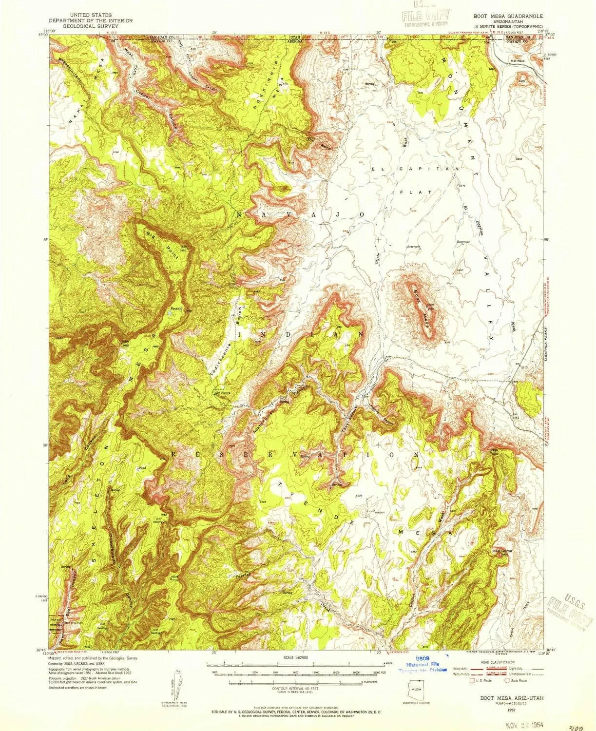
  • USGS topographic map of Boot Mesa, AZ, at 1:62500 scale. Lighter material. Waterproof. Tear-resistant. Foldable. Very durable. Perfect for backpacking and the outdoors.
  • Cities, towns, villages: Please see map preview to find populated places, townships, as well as roads and street names if available.
  • Mountains: Big Point,Tyende Mesa,Hat Rock,Segeke Butte,The Ramp,Boot Mesa,Nokai Mesa,Hoskinnini Mesa,Azansosi Mesa
  • Valleys: Segihatsosi Canyon,Adahchijiyahi Canyon,Laughing Canyon


USGS topographic map of Boot Mesa, Arizona, dated 1952, updated 1954.

Includes geographic coordinates (latitude and longitude), lines of elevation, bodies of water, roads, and more. This topo quad is suitable for recreational, outdoor uses, office applications, or wall map framing.

Printed on-demand by YellowMaps on the print material of your choice.

Shipping rolled from Minneapolis, MN, United States.

Product Number: USGS-5547566
Map Size: 20.8 inches high x 16.9 inches wide
Map Scale: 1:62500
Map Type: POD USGS Topographic Map
Map Series: HTMC
Map Version: Historical
Cell ID: 51644
Scan ID: 314405
Imprint Year: 1954
Woodland Tint: Yes
Aerial Photo Year: 1951
Field Check Year: 1952
Datum: NAD27
Map Projection: Polyconic
Map published by United States Geological Survey
Map Language: English
Scanner Resolution: 600 dpi
Map Cell Name: Boot Mesa
Grid size: 15 X 15 Minute
Date on map: 1952
Geographical region: Arizona, United States
Northern map edge Latitude: 37°
Southern map edge Latitude: 36.75°
Western map edge Longitude: -110.5°
Eastern map edge Longitude: -110.25°

Surrounding map sheets (copy & paste the Product No. in the search bar):
North: USGS-5458189,USGS-5462789,USGS-5462787,USGS-5456391
East: USGS-5549718,USGS-5547368,USGS-5547366,USGS-5549708,USGS-5547364
South: USGS-5553678
West: USGS-5556434,USGS-5556432

You May Also Like

Barska BE12746 Winbest Pro-200 Metal Detector Field Kit with LED Indicator, Headphone, Shovel, and Soft Case, Black

$ 55.00

$ 78.00

Save: $

Fire-Fast Firefly - by Great Ape Empire

$ 35.00

Save: $

Camping Tent,Pop Up Instant Tents,Family Camping Tent 4-6 Person Automatic Tents for Camping,Outdoor,Backyard

$ 128.00

$ 365.00

Save: $

Nite Ize Radiant® 200 Headlamp

$ 26.99

Save: $

Atlas & Green World Travel Map   Bonus Europe Poster. Premium Scratch Off World Map Poster. Watercolor Travel Scratch Off Map with all US States and Gift Tube
Atlas & Green World Travel Map Bonus Europe Poster. Premium Scratch Off World Map Poster. Watercolor Travel Scratch Off Map with all US States and Gift Tube

$ 14.00

$ 17.00

Save: $

Parashark Pro Knife
Parashark Pro Knife

$ 24.99

Save: $

Lacombe LA topo map, 1:24000 Scale, 7.5 X 7.5 Minute, Historical, 1998, Updated 2001, 26.7 x 21.6 in

$ 45.00

$ 64.00

Save: $

Germany Wall Map - Published 1991 by National Geographic

$ 49.95

Save: $

Flag Ecuador Coat Arms Accurate Foldable Beach Cabana UPF50  Protection Lightweight Large Portable Sun Shelter with Sand Shovel, Sandbags for Family Travel
Flag Ecuador Coat Arms Accurate Foldable Beach Cabana UPF50 Protection Lightweight Large Portable Sun Shelter with Sand Shovel, Sandbags for Family Travel

$ 60.00

$ 110.00

Save: $

Streamlight 61601 Double Clutch USB 125-Lumen Multi-Fuel LED Headlamp with Elastic Head Strap, Rubber Hard Hat Strap, and USB Cable, Black

$ 35.00

$ 50.00

Save: $

Cart
Cooking Essentials&Outdoor Tools|Foldable Shovels,Windproof Stoves&Headlamps
Your cart is currently empty.