Cooking Essentials&Outdoor Tools|Foldable Shovels,Windproof Stoves&Headlamps
Cooking Essentials&Outdoor Tools|Foldable Shovels,Windproof Stoves&Headlamps Cooking Essentials&Outdoor Tools|Foldable Shovels,Windproof Stoves&Headlamps
Home Navigation Gear Waterproof Hiking Map
Alpine WY topo map, 1:24000 Scale, 7.5 X 7.5 Minute, Historical, 1966, Updated 1998, 26.9 x 21.6 in

Alpine WY topo map, 1:24000 Scale, 7.5 X 7.5 Minute, Historical, 1966, Updated 1998, 26.9 x 21.6 in

$ 48.00

$ 69.00

Save: $

Color:
  • Polypropylene
  • Regular Paper
  • Tyvek
Unavailable
Please select combo product attributes
The combo subtotal is $,SAVE$

Product Details

  • Printed on Tyvek® (synthetic)
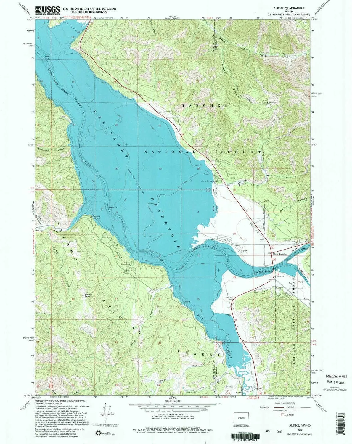
  • USGS topographic map of Alpine, WY, at 1:24000 scale. Lighter material. Waterproof. Tear-resistant. Foldable. Very durable. Perfect for backpacking and the outdoors.
  • Cities, towns, villages: Alpine Junction,Alpine
  • Mountains: Bitters Peak
  • Valleys: Grand Valley,Driveway Canyon,Little Box Canyon,Jordan Canyon,Long Spring Canyon,Grand Canyon


USGS topographic map of Alpine, Wyoming, dated 1966, updated 1998.

Includes geographic coordinates (latitude and longitude), lines of elevation, bodies of water, roads, and more. This topo quad is suitable for recreational, outdoor uses, office applications, or wall map framing.

Printed on-demand by YellowMaps on the print material of your choice.

Shipping rolled from Minneapolis, MN, United States.

Product Number: USGS-5609376
Map Size: 26.9 inches high x 21.6 inches wide
Map Scale: 1:24000
Map Type: POD USGS Topographic Map
Map Series: HTMC
Map Version: Historical
Cell ID: 697
Scan ID: 338249
Imprint Year: 1998
Woodland Tint: Yes
Aerial Photo Year: 1965
Field Check Year: 1966
Datum: NAD27
Map Projection: Lambert Conformal Conic
Map published by United States Geological Survey
Map Language: English
Scanner Resolution: 600 dpi
Map Cell Name: Alpine
Grid size: 7.5 X 7.5 Minute
Date on map: 1966
Geographical region: Wyoming, United States
Northern map edge Latitude: 43.25°
Southern map edge Latitude: 43.125°
Western map edge Longitude: -111.125°
Eastern map edge Longitude: -111°

Surrounding map sheets (copy & paste the Product No. in the search bar):
North: USGS-5433890,USGS-5433888
East: USGS-5611786,USGS-5611790,USGS-5611788
South: USGS-5431865,USGS-5431863
West: USGS-5434587,USGS-5434589

You May Also Like

Non-Stick Pizza Shovel - Sliding Kitchen Gadget for Smooth Cutting & Transfer

$ 30.69

Save: $

YOUNGDO Folding Shovel, Camping Survival Shovel with Pickaxe, Tactical Entrenching Tool for Digging, Backpacking, Hiking, Gardening, Car Emergency, Metal Detector Accessories

$ 16.00

$ 20.00

Save: $

Foldable Stove Portable Outdoor Compact Camping for Hiking Andnics Cookingsils/A03

$ 36.00

$ 51.00

Save: $

OLIGHT Perun 3 Rechargeable Headlamp Flashlight, 3000 Lumens LED Headlight with Red Light Bundle with Oclip Rechargeable EDC Flashlight 300 Lumens Dual Light Sources Compact Pocket Clip Light

$ 59.00

$ 108.00

Save: $

Benchmark Maps: New Mexico Recreation Wall Map - 26 x 33 inches - Art Quality Print on Polypropylene

$ 31.00

$ 45.00

Save: $

Picnic Table Cover with Bench Covers Elastic Edges, American Flag Fitted Table Cover, Outdoor Patio Camping Essentials 72 Inch 3PCS, Waterproof Camping Fitted Tablecloth with Drawstring Bag

$ 19.00

$ 24.00

Save: $

Western Austalia Historical Gold Field Maps - Kurnalpi

$ 69.95

Save: $

Men's Cycling Rain Jackets Waterproof Running Bike Windbreaker Lightweight Packable Hooded Jacket

$ 35.00

$ 50.00

Save: $

5W Portable LED Headlight Plastic Clip Carry with Filter for Magnifier Loupes (Gray)

$ 28.00

$ 40.00

Save: $

Kennebago Lake ME topo map, 1:48000 Scale, 15 X 15 Minute, Historical, 1932, 27.4 x 19.3 in

$ 52.00

$ 74.00

Save: $

Cart
Cooking Essentials&Outdoor Tools|Foldable Shovels,Windproof Stoves&Headlamps
Your cart is currently empty.