- Printed on Tyvek® (synthetic)
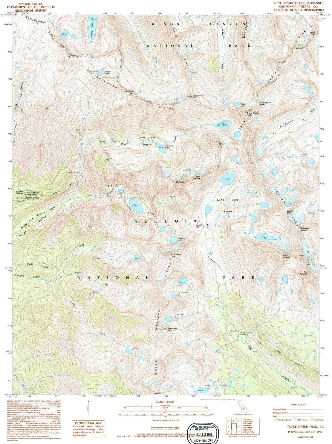
- USGS topographic map of Triple Divide Peak, CA, at 1:24000 scale. Lighter material. Waterproof. Tear-resistant. Foldable. Very durable. Perfect for backpacking and the outdoors.
- Cities, towns, villages: Please see map preview to find populated places, townships, as well as roads and street names if available.
- Mountains: Eagle Scout Peak,Black Kaweah,Lawson Peak,Lippincott Mountain,Kaweah Queen,Mount Stewart,Red Kaweah,Triple Divide Peak
- Valleys: Valhalla
USGS topographic map of Triple Divide Peak, California, dated 1993, updated 1994.
Includes geographic coordinates (latitude and longitude), lines of elevation, bodies of water, roads, and more. This topo quad is suitable for recreational, outdoor uses, office applications, or wall map framing.
Printed on-demand by YellowMaps on the print material of your choice.
Shipping rolled from Minneapolis, MN, United States.
Product Number: USGS-5524889
Map Size: 26.7 inches high x 21.4 inches wide
Map Scale: 1:24000
Map Type: POD USGS Topographic Map
Map Series: HTMC
Map Version: Historical
Cell ID: 45704
Scan ID: 295523
Imprint Year: 1994
Woodland Tint: Yes
Visual Version Number: 1
Aerial Photo Year: 1993
Datum: NAD27
Map Projection: Lambert Conformal Conic
Provisional map: Yes
Map published by United States Geological Survey
Map Language: English
Scanner Resolution: 600 dpi
Map Cell Name: Triple Divide Peak
Grid size: 7.5 X 7.5 Minute
Date on map: 1993
Geographical region: California, United States
Northern map edge Latitude: 36.625°
Southern map edge Latitude: 36.5°
Western map edge Longitude: -118.625°
Eastern map edge Longitude: -118.5°
Surrounding map sheets (copy & paste the Product No. in the search bar):
North: USGS-5523799,USGS-5523797
East: USGS-5506081,USGS-5519199,USGS-5506071,USGS-5506063,USGS-5503127
South: USGS-5518581,USGS-5518579,USGS-5518583,USGS-5518585
West: USGS-5517511,USGS-5517513


 Hunting Headlamp IPX5 Waterproof Rechargeable Camping Hiking Fishing Bright Head Light, 4 Optical Filters for Coon, Coyote, Hog, Ducks Hunting")


