- Printed on Polypropylene (plastic)
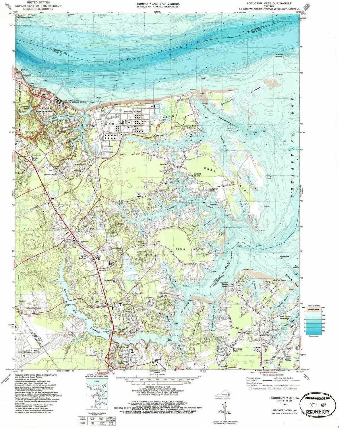
- USGS topographic map of Poquoson West, VA, at 1:24000 scale. Heavier material. Waterproof. Tear-resistant. Foldable. Perfect for the outdoors.
- Cities, towns, villages: Hornsbyville,Dalbytown,Barcroft,Piney Point Estates,Lakeside Homes,Kentucky Farms,Marlbank,Burts,Grafton,Harwoods Mill,Moores,Goodwin Neck Estates,Poquoson River Estates,Freemoor Estates,Evergreen Shores,Rivergate,La Tierra,Holly Hills,Heritage Hamlet,Harris Grove,Battle Park,Yorkville,Poor Farm,York Haven Anchorage,Acree Acres,Mill Farms,Dare,Nelson Heights,Poquoson Shores,Seaford Shores,Powhatan Place,Robanna Shores,Seaford,Edgehill,Dandy
- Islands: Goodwin Islands
- Parks and forests: Chisman Creek Park,Back Creek Park,Wolf Trap Park,Newport News Park
USGS topographic map of Poquoson West, Virginia, dated 1983, updated 1987.
Includes geographic coordinates (latitude and longitude), lines of elevation, bodies of water, roads, and more. This topo quad is suitable for recreational, outdoor uses, office applications, or wall map framing.
Printed on-demand by YellowMaps on the print material of your choice.
Shipping rolled from Minneapolis, MN, United States.
Product Number: USGS-5300404
Map Size: 27.5 inches high x 21.9 inches wide
Map Scale: 1:24000
Map Type: POD USGS Topographic Map
Map Series: HTMC
Map Version: Historical
Cell ID: 35999
Scan ID: 186318
Imprint Year: 1987
Woodland Tint: Yes
Aerial Photo Year: 1963
Field Check Year: 1964
Datum: NAD27
Map Projection: Polyconic
Map published by United States Geological Survey
Map Language: English
Scanner Resolution: 600 dpi
Map Cell Name: Poquoson West
Grid size: 7.5 X 7.5 Minute
Date on map: 1983
Geographical region: Virginia, United States
Northern map edge Latitude: 37.25°
Southern map edge Latitude: 37.125°
Western map edge Longitude: -76.5°
Eastern map edge Longitude: -76.375°
Surrounding map sheets (copy & paste the Product No. in the search bar):
North: USGS-5296143,USGS-5303084,USGS-5296135,USGS-5303088,USGS-5296137
East: USGS-5300388,USGS-5300386,USGS-5300384,USGS-5299612,USGS-5300390
South: USGS-5299974,USGS-5299980,USGS-5299978,USGS-5299972,USGS-5299976
West: USGS-5953373,USGS-5302160,USGS-5953371,USGS-5302158,USGS-5302150


 s1a")


