Cooking Essentials&Outdoor Tools|Foldable Shovels,Windproof Stoves&Headlamps
Cooking Essentials&Outdoor Tools|Foldable Shovels,Windproof Stoves&Headlamps Cooking Essentials&Outdoor Tools|Foldable Shovels,Windproof Stoves&Headlamps
Home Navigation Gear Waterproof Hiking Map
Nicatous Lake ME topo map, 1:62500 Scale, 15 X 15 Minute, Historical, 1934, Updated 1948, 20.9 x 17 in

Nicatous Lake ME topo map, 1:62500 Scale, 15 X 15 Minute, Historical, 1934, Updated 1948, 20.9 x 17 in

$ 45.00

$ 64.00

Save: $

Color:
  • Polypropylene
  • Regular Paper
  • Tyvek
Unavailable
Please select combo product attributes
The combo subtotal is $,SAVE$

Product Details

  • Printed on Polypropylene (plastic)
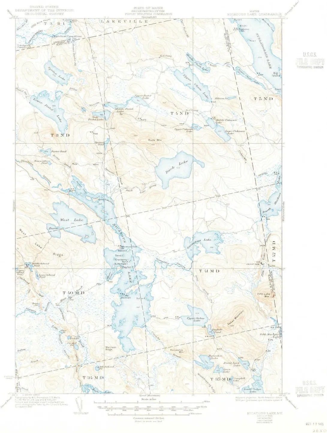
  • USGS topographic map of Nicatous Lake, ME, at 1:62500 scale. Heavier material. Waterproof. Tear-resistant. Foldable. Perfect for the outdoors.
  • Cities, towns, villages: Please see map preview to find populated places, townships, as well as roads and street names if available.
  • Islands: Pine Island,Dayton Island,Butterfield Island,Cranberry Island,Chain Island,Bacon Island,Dollar Island,Sand Island
  • Parks and forests: National Parks, National Forests, etc. Please preview map image for specifics.


USGS topographic map of Nicatous Lake, Maine, dated 1934, updated 1948.

Includes geographic coordinates (latitude and longitude), lines of elevation, bodies of water, roads, and more. This topo quad is suitable for recreational, outdoor uses, office applications, or wall map framing.

Printed on-demand by YellowMaps on the print material of your choice.

Shipping rolled from Minneapolis, MN, United States.

Product Number: USGS-5684747
Map Size: 20.9 inches high x 17 inches wide
Map Scale: 1:62500
Map Type: POD USGS Topographic Map
Map Series: HTMC
Map Version: Historical
Cell ID: 58430
Scan ID: 460664
Imprint Year: 1948
Edit Year: 1941
Survey Year: 1932
Datum: NAD
Map Projection: Polyconic
Map published by United States Geological Survey
Map Language: English
Scanner Resolution: 600 dpi
Map Cell Name: Nicatous Lake
Grid size: 15 X 15 Minute
Date on map: 1934
Geographical region: Maine, United States
Northern map edge Latitude: 45.25°
Southern map edge Latitude: 45°
Western map edge Longitude: -68.25°
Eastern map edge Longitude: -68°

Surrounding map sheets (copy & paste the Product No. in the search bar):
North: USGS-5535385,USGS-5537115,USGS-5685225,USGS-5537117,USGS-5685227
East: USGS-5685403,USGS-5533753,USGS-5631193,USGS-5631191,USGS-5535631
South: USGS-5536669,USGS-5532993,USGS-5536671,USGS-5637993,USGS-5684511
West: USGS-5685075,USGS-5535979,USGS-5533247,USGS-5685081,USGS-5535173

You May Also Like

Salewa Men's Pedroc Pro Powertex Waterproof Trekking & Hiking Boot

$ 200.00

Save: $

Portable Camping Hiking Traveling Picnic Shovel - Multifunctional Ordnance Shovel Survival Outdoor Equipment Garden Tool Shovel

$ 27.90

Save: $

ust Brila 450 LED Headlamp, Black, One Size

$ 24.00

$ 30.00

Save: $

William Morris S Design Leopard Beach Cabana UPF50 Waterproof Outdoor Sun Shade with Sand Shovel, Sandbags for Camping, Picnics, Backyard

$ 61.00

$ 111.00

Save: $

USGI Gerber Tri-folding Shovel

$ 123.00

Save: $

USGI Industries Military Style Shovel | Tri-Fold Entrenching Tool with Serrated Edge | Lightweight, Foldable, Compact, Multi-Use Perfect for Camping, Survival, Trenching (OCP Cover)

$ 28.00

$ 40.00

Save: $

Headlamp, H4C Headlamp Rechargeable 2Pack with White & Yellow & Red & Green Floodlight & Spotlight Mini Portable with Motion Sensor Super for Camping Running Fishing Climbing Hiking Maintenance

$ 24.00

$ 30.00

Save: $

Outdoor Portable Bbq Grill with Mesh Accessory Durable Iron Alloy Design for Camping Tailgating Easy to Resistant for Bonfire Activities and Backyard

$ 37.00

$ 52.00

Save: $

Little Donkey Andy Men's Warm Sherpa Lined Winter Softshell Jacket Windproof Mountain Ski Snow Coat with Removable Hood

$ 53.00

$ 76.00

Save: $

Soonwald-Nahe 2 Bad Kreuznach: Hiking Map with Cycle Paths, Sheet 41-552, 1: 25,000, Bad Sobernheim, Stromberg, Lower Naheland (NaturNavi Hiking Map with Cycle Paths 1:25 000)

$ 13.00

$ 16.00

Save: $

Cart
Cooking Essentials&Outdoor Tools|Foldable Shovels,Windproof Stoves&Headlamps
Your cart is currently empty.