Cooking Essentials&Outdoor Tools|Foldable Shovels,Windproof Stoves&Headlamps
Cooking Essentials&Outdoor Tools|Foldable Shovels,Windproof Stoves&Headlamps Cooking Essentials&Outdoor Tools|Foldable Shovels,Windproof Stoves&Headlamps
Home Navigation Gear Waterproof Hiking Map
Lake Benton MN topo map, 1:24000 Scale, 7.5 X 7.5 Minute, Historical, 1967, Updated 1968, 27.23 x 21.53 in

Lake Benton MN topo map, 1:24000 Scale, 7.5 X 7.5 Minute, Historical, 1967, Updated 1968, 27.23 x 21.53 in

$ 48.00

$ 69.00

Save: $

Color:
  • Polypropylene
  • Regular Paper
  • Tyvek
Unavailable
Please select combo product attributes
The combo subtotal is $,SAVE$

Product Details

  • Printed on Tyvek® (synthetic)
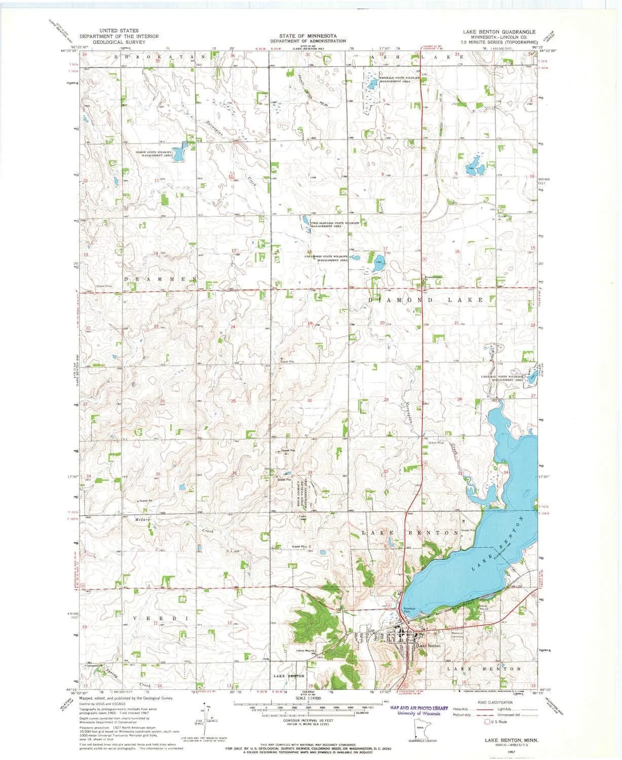
  • USGS topographic map of Lake Benton, MN, at 1:24000 scale. Lighter material. Waterproof. Tear-resistant. Foldable. Very durable. Perfect for backpacking and the outdoors.
  • Cities, towns, villages: Lake Benton
  • Mountains: High elevation topographical features like high summits and peaks.
  • Valleys: Low elevation topographic features such as flatlands, river valleys, and canyons.


USGS topographic map of Lake Benton, Minnesota, dated 1967, updated 1968.

Includes geographic coordinates (latitude and longitude), lines of elevation, bodies of water, roads, and more. This topo quad is suitable for recreational, outdoor uses, office applications, or wall map framing.

Printed on-demand by YellowMaps on the print material of your choice.

Shipping rolled from Minneapolis, MN, United States.

Product Number: USGS-5987756
Map Size: 27.23 inches high x 21.53 inches wide
Map Scale: 1:24000
Map Type: POD USGS Topographic Map
Map Series: HTMC
Map Version: Historical
Cell ID: 24342
Scan ID: 504977
Imprint Year: 1968
Woodland Tint: Yes
Aerial Photo Year: 1965
Field Check Year: 1967
Datum: NAD27
Map Projection: Polyconic
Map published by United States Geological Survey
Map Language: English
Scanner Resolution: 508 dpi
Map Cell Name: Lake Benton
Grid size: 7.5 X 7.5 Minute
Date on map: 1967
Geographical region: Minnesota, United States
Northern map edge Latitude: 44.375°
Southern map edge Latitude: 44.25°
Western map edge Longitude: -96.375°
Eastern map edge Longitude: -96.25°

Surrounding map sheets (copy & paste the Product No. in the search bar):
North: USGS-5987748
East: USGS-5989274
South: USGS-5989308
West: USGS-5987754

You May Also Like

Folding Outdoor Camping Stove Portable Stainless Steel Stove Wood Picnic Gas Burner for Outdoor Hiking Picnic BBQ

$ 27.00

$ 38.00

Save: $

Green Gradient Beach Canopy UPF50  Protection Lightweight Portable Sunshade with Sturdy Poles, Sandbags and Shovel for Backyard and Camping
Green Gradient Beach Canopy UPF50 Protection Lightweight Portable Sunshade with Sturdy Poles, Sandbags and Shovel for Backyard and Camping

$ 60.00

$ 110.00

Save: $

Little Donkey Andy Men's Lightweight Softshell Vest Windproof Sleeveless Jacket for Travel Hiking Running Golf

$ 30.00

$ 43.00

Save: $

National Geographic Scotland Wall Map - Classic - Laminated (30 x 36 in) (National Geographic Reference Map) Map – December 13, 2017

$ 20.00

$ 25.00

Save: $

Little Donkey Andy Women's Waterproof Hiking Skiing Jacket with Removable Hood, Fleece Lined Winter Warm Rain Coat

$ 28.00

$ 40.00

Save: $

Brotherhood Without Banners: Starter Set

$ 104.00

Save: $

Dallas - Fort Worth Metroplex Detailed Regional Wall Map w/ZIP Codes *Ready-to-Hang* JUMBO 64"?48" [Map] Shane Murphy

$ 209.95

Save: $

Tinder Hot Box Solar Fire Starter

$ 43.16

Save: $

Pacific Ocean, and the Bay of Bengal Wall Map - Published 1943 by National Geographic

$ 69.95

Save: $

Folding Shovel, Collapsible Camping Shovel (24.21''), Survival Multitool with Pickaxe, Lightweight Portable Tactical Spade for Hiking, Camping, Trenching, Gardening and Backpacking

$ 22.00

$ 28.00

Save: $

Cart
Cooking Essentials&Outdoor Tools|Foldable Shovels,Windproof Stoves&Headlamps
Your cart is currently empty.