- Printed on Polypropylene (plastic)
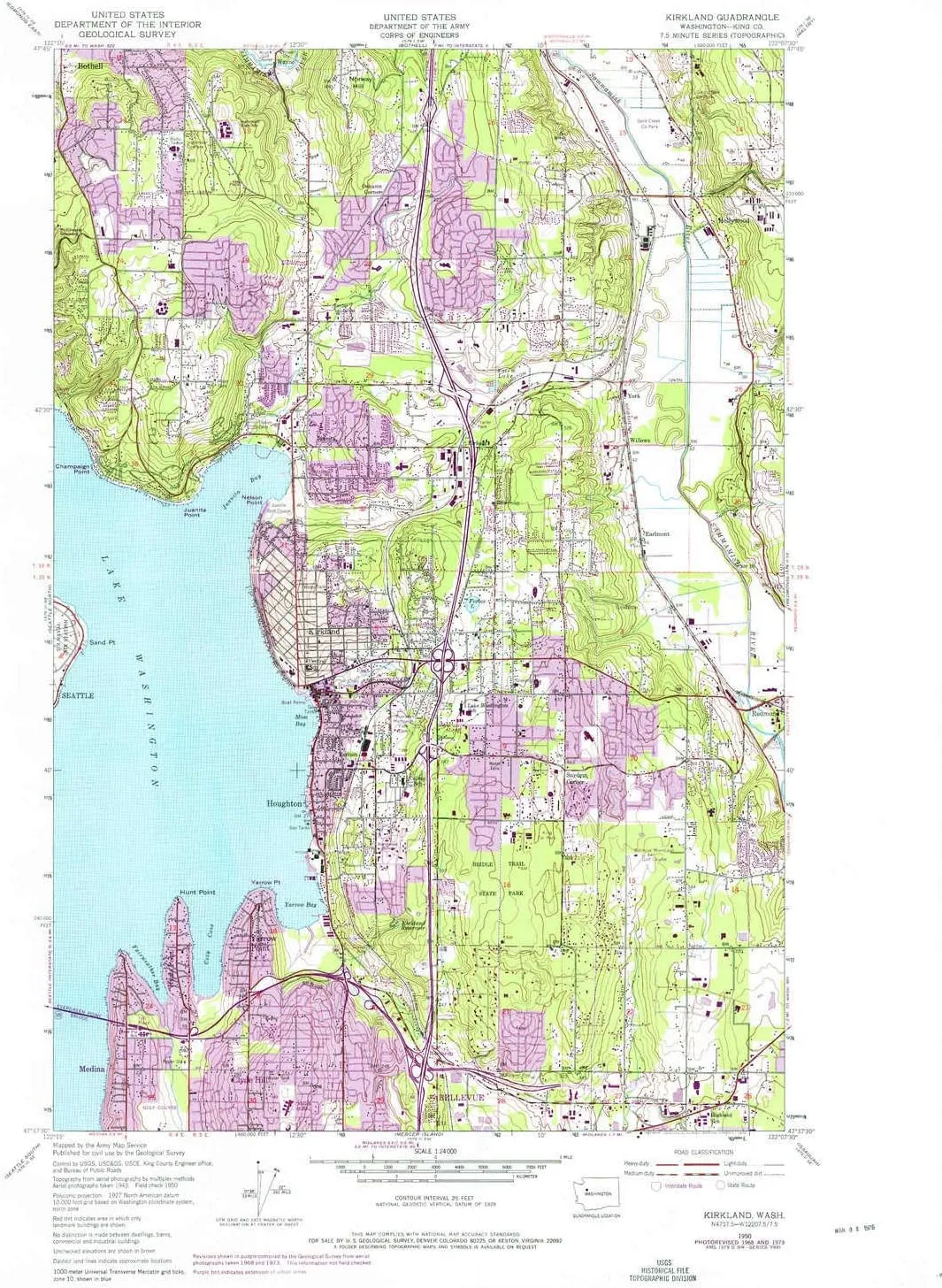
- USGS topographic map of Kirkland, WA, at 1:24000 scale. Heavier material. Waterproof. Tear-resistant. Foldable. Perfect for the outdoors.
- Cities, towns, villages: Lake Park,Snyders Corner,Hunts Point,Oskams Corner,Feriton,Northrup,Earlmont,Hollywood Hill,Moorlands,Juanita,Inglewood,Willows,Wayne,York,Houghton,Boddy,Kingsgate,Lucerne,Ashwood,Firloch,Hollywood,Finn Hill,Rose Hill,Overlake,Yarrow Point,Clyde Hill,Kirkland
- Islands: Consult topo map preview for visible islands.
- Parks and forests: Bridle Trails State Park,Fairweather Park,Cherry Crest Park,Big Finn Hill Park,Morningside Park,King County Park,Willows Creek Neighborhood Park,Spring Hills Park,Kiwanis Park,Inglemoor County Park,E Norway Hill Park,Juanita Beach Park,Mark Twain Park,Westside Park,North Towne Park,Northwest Community Center Park,Bellevue Highlands Park,Gold Creek County Park,Edith Moulton Park,O O Denny Park,Marsh Park,Waverly Park,Sammamish River Regional Park,Crestwoods Park
USGS topographic map of Kirkland, Washington, dated 1950, updated 1976.
Includes geographic coordinates (latitude and longitude), lines of elevation, bodies of water, roads, and more. This topo quad is suitable for recreational, outdoor uses, office applications, or wall map framing.
Printed on-demand by YellowMaps on the print material of your choice.
Shipping rolled from Minneapolis, MN, United States.
Product Number: USGS-5405084
Map Size: 28 inches high x 22.1 inches wide
Map Scale: 1:24000
Map Type: POD USGS Topographic Map
Map Series: HTMC
Map Version: Historical
Cell ID: 23742
Scan ID: 241782
Imprint Year: 1976
Woodland Tint: Yes
Photo Revision Year: 1973
Aerial Photo Year: 1973
Field Check Year: 1950
Datum: NAD27
Map Projection: Polyconic
Map published by United States Geological Survey
Map published by United States Army Corps of Engineers
Map published by United States Army
Map Language: English
Scanner Resolution: 600 dpi
Map Cell Name: Kirkland
Grid size: 7.5 X 7.5 Minute
Date on map: 1950
Geographical region: Washington, United States
Northern map edge Latitude: 47.75°
Southern map edge Latitude: 47.625°
Western map edge Longitude: -122.25°
Eastern map edge Longitude: -122.125°
Surrounding map sheets (copy & paste the Product No. in the search bar):
North: USGS-5409804,USGS-5402892,USGS-5409802,USGS-5402890,USGS-5402896
East: USGS-5407574,USGS-5407578,USGS-5407580,USGS-5407576
South: USGS-5409440,USGS-5406304,USGS-5406302,USGS-5406300,USGS-5406306
West: USGS-5409446,USGS-5932329,USGS-5932327,USGS-5932331,USGS-5409448


 by QPA")


