- Printed on Tyvek® (synthetic)
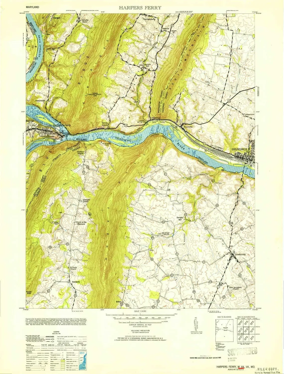
- USGS topographic map of Harpers Ferry, WV, at 1:24000 scale. Lighter material. Waterproof. Tear-resistant. Foldable. Very durable. Perfect for backpacking and the outdoors.
- Cities, towns, villages: Lovettsville,Lower Town,Augusta,Weverton,Garretts Mill,Stonebraker (historical),Harpers Ferry,Pomona,Knoxville,Pleasantville,Yarrowsburg,Neersville,Rice,Brunswick,Springdale,Pine Hill Estates,Roelkeys Knoll,Loudoun Heights,Sandy Hook,Keister,Bolington,Britain,Water Acres,New Addition,Elvan,Samples Manor,Georges Mill,Virginius (historical)
- Mountains: Camp Hill,Buzzard Rock,Loudoun Heights,Maryland Heights,White Rock,Purcell Knob
- Valleys: Pleasant Valley,Loudoun Valley
USGS topographic map of Harpers Ferry, West Virginia, dated 1953.
Includes geographic coordinates (latitude and longitude), lines of elevation, bodies of water, roads, and more. This topo quad is suitable for recreational, outdoor uses, office applications, or wall map framing.
Printed on-demand by YellowMaps on the print material of your choice.
Shipping rolled from Minneapolis, MN, United States.
Product Number: USGS-5413040
Map Size: 28.9 inches high x 21.9 inches wide
Map Scale: 1:24000
Map Type: POD USGS Topographic Map
Map Series: HTMC
Map Version: Historical
Cell ID: 19389
Scan ID: 252994
Woodland Tint: Yes
Aerial Photo Year: 1943
Field Check Year: 1944
Datum: NAD27
Map Projection: Polyconic
Map published by United States Army
Map Language: English
Scanner Resolution: 600 dpi
Map Cell Name: Harpers Ferry
Grid size: 7.5 X 7.5 Minute
Date on map: 1953
Geographical region: West Virginia, United States
Northern map edge Latitude: 39.375°
Southern map edge Latitude: 39.25°
Western map edge Longitude: -77.75°
Eastern map edge Longitude: -77.625°
Surrounding map sheets (copy & paste the Product No. in the search bar):
North: USGS-5366520,USGS-5366528,USGS-5930439,USGS-5930435,USGS-5366522
East: USGS-5367788,USGS-5367010,USGS-5367016,USGS-5930541,USGS-5367018
South: USGS-5300526,USGS-5300530,USGS-5302388,USGS-5300528,USGS-5300532
West: USGS-5412502,USGS-5415548,USGS-5412508,USGS-5412506,USGS-5412510


