Cooking Essentials&Outdoor Tools|Foldable Shovels,Windproof Stoves&Headlamps
Cooking Essentials&Outdoor Tools|Foldable Shovels,Windproof Stoves&Headlamps Cooking Essentials&Outdoor Tools|Foldable Shovels,Windproof Stoves&Headlamps
Home Navigation Gear Waterproof Hiking Map
Grovetown GA topo map, 1:24000 Scale, 7.5 X 7.5 Minute, Historical, 1957, Updated 1980, 26.9 x 22 in

Grovetown GA topo map, 1:24000 Scale, 7.5 X 7.5 Minute, Historical, 1957, Updated 1980, 26.9 x 22 in

$ 52.00

$ 74.00

Save: $

Color:
  • Polypropylene
  • Regular Paper
  • Tyvek
Unavailable
Please select combo product attributes
The combo subtotal is $,SAVE$

Product Details

  • Printed on Polypropylene (plastic)
  • USGS topographic map of Grovetown, GA, at 1:24000 scale. Heavier material. Waterproof. Tear-resistant. Foldable. Perfect for the outdoors.
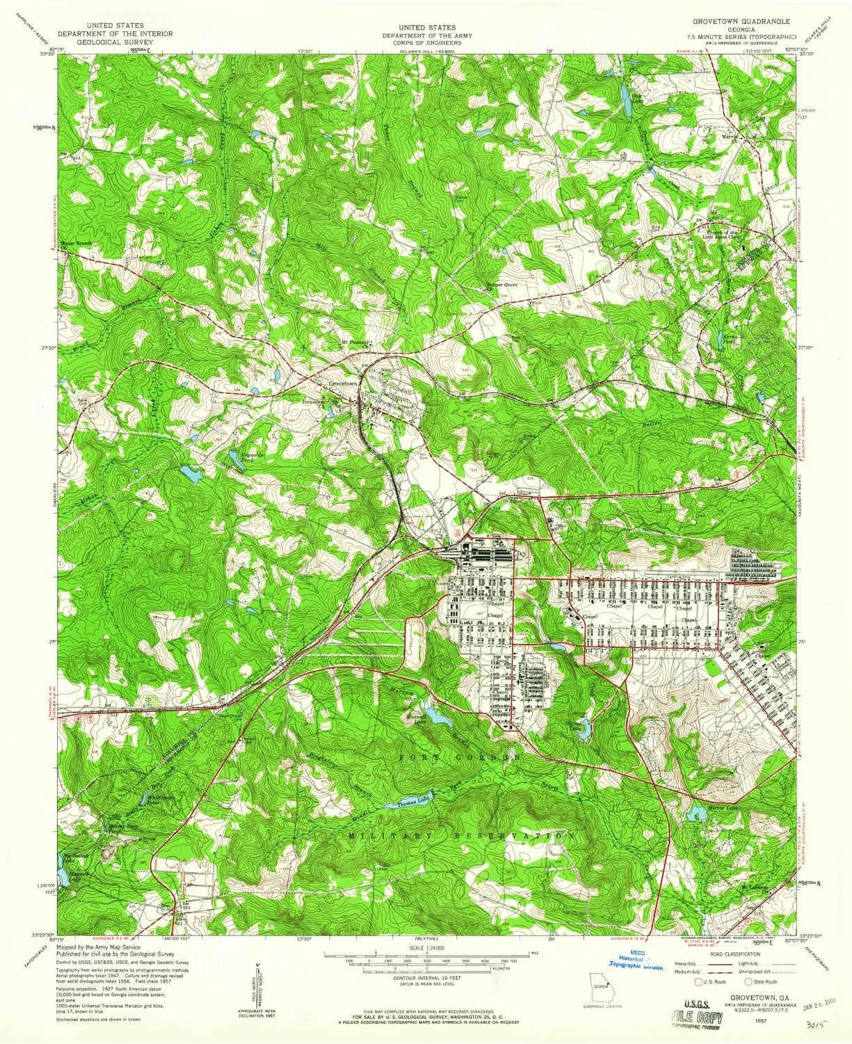
  • Cities, towns, villages: Maple Creek,Grovetown,Sugarcreek,Blanchard Park,Westmont,Belglade,Olive Terrace,Fort Gordon,Quail Creek,Kettle Creek,Avery Landing,Forrest (historical),Kensington,Ridge Point,Lewiston Downs,Silver Maple Ridge,Buffalo Ranch,Ridge Crossing,Lake Royal,Smithwick,Oak Lake,Tower Pines
  • Islands: Consult topo map preview for visible islands.
  • Parks and forests: National Parks, National Forests, etc. Please preview map image for specifics.


USGS topographic map of Grovetown, Georgia, dated 1957, updated 1980.

Includes geographic coordinates (latitude and longitude), lines of elevation, bodies of water, roads, and more. This topo quad is suitable for recreational, outdoor uses, office applications, or wall map framing.

Printed on-demand by YellowMaps on the print material of your choice.

Shipping rolled from Minneapolis, MN, United States.

Product Number: USGS-5362020
Map Size: 26.9 inches high x 22 inches wide
Map Scale: 1:24000
Map Type: POD USGS Topographic Map
Map Series: HTMC
Map Version: Historical
Cell ID: 70267
Scan ID: 245832
Imprint Year: 1980
Woodland Tint: Yes
Aerial Photo Year: 1956
Field Check Year: 1957
Datum: NAD27
Map Projection: Polyconic
Map published by United States Army Corps of Engineers
Map Language: English
Scanner Resolution: 600 dpi
Map Cell Name: Grovetown
Grid size: 7.5 X 7.5 Minute
Date on map: 1957
Geographical region: Georgia, United States
Northern map edge Latitude: 33.5°
Southern map edge Latitude: 33.375°
Western map edge Longitude: -82.25°
Eastern map edge Longitude: -82.125°

Surrounding map sheets (copy & paste the Product No. in the search bar):
North: USGS-5361716,USGS-5361718,USGS-5388694,USGS-5659436,USGS-5388688
East: USGS-5360456,USGS-5360462,USGS-5360464,USGS-5360458,USGS-5360460
South: USGS-5360696,USGS-5360692,USGS-5360688,USGS-5360694,USGS-5360690
West: USGS-5362060,USGS-5362062,USGS-5362064

You May Also Like

Energizer LED Headlamp Pro260, Rugged IPX4 Water Resistant Head Light, Ultra Bright Headlamps for Running, Camping, Outdoor, Storm Power Outage (Batteries Included)

$ 16.00

Save: $

BWCA Map - BWCA 10 – Waterproof, Durable Cloth Map for Canoeing, Hiking, and Camping by True North Map Company

$ 24.00

$ 30.00

Save: $

LED Head Light Lamp 3.5X Binocular Loupes 5W Spot Brightness Adjustable for Lab Headlamp Headlight

$ 59.00

$ 99.00

Save: $

Adirondack Park Map: NORTHVILLE, RAQUETTE LAKE ADIRONDACK PARK MAP #744

$ 14.95

Save: $

Little Donkey Andy Men's Lightweight Softshell Vest Windproof Sleeveless Jacket for Travel Hiking Running Golf

$ 31.00

$ 45.00

Save: $

Montezuma SE KS topo map, 1:24000 Scale, 7.5 X 7.5 Minute, Historical, 1969, Updated 1971, 26.68 x 20.62 in

$ 48.00

$ 69.00

Save: $

Camping Chairs Folding Reclining Camping Chair Camping Lounge Chair for Travel Hiking

$ 210.00

$ 600.00

Save: $

Vintage Lighter Retro Trench Rattler Rope Velvet Metal Outdoor Camping Igniter Portable Mechanical Tinder Flint No Kerosene for Men(#fedb88)

$ 20.00

$ 24.00

Save: $

London Historic Wall Map 1886 published with the Australian Map Book

$ 59.95

Save: $

Portable Outdoor Cooking System

$ 167.99

Save: $

Cart
Cooking Essentials&Outdoor Tools|Foldable Shovels,Windproof Stoves&Headlamps
Your cart is currently empty.