Cooking Essentials&Outdoor Tools|Foldable Shovels,Windproof Stoves&Headlamps
Cooking Essentials&Outdoor Tools|Foldable Shovels,Windproof Stoves&Headlamps Cooking Essentials&Outdoor Tools|Foldable Shovels,Windproof Stoves&Headlamps
Home Navigation Gear Waterproof Hiking Map
Glide OR topo map, 1:62500 Scale, 15 X 15 Minute, Historical, 1954, Updated 1957, 20.8 x 16.4 in

Glide OR topo map, 1:62500 Scale, 15 X 15 Minute, Historical, 1954, Updated 1957, 20.8 x 16.4 in

$ 45.00

$ 64.00

Save: $

Color:
  • Polypropylene
  • Regular Paper
  • Tyvek
Unavailable
Please select combo product attributes
The combo subtotal is $,SAVE$

Product Details

  • Printed on Polypropylene (plastic)
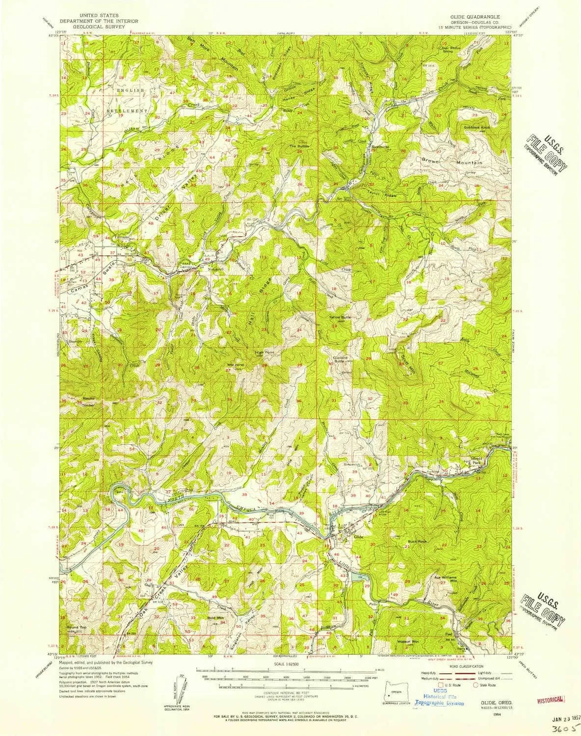
  • USGS topographic map of Glide, OR, at 1:62500 scale. Heavier material. Waterproof. Tear-resistant. Foldable. Perfect for the outdoors.
  • Cities, towns, villages: Hoaglin (historical),Rockland (historical),Glide,Fair Oaks,Oak Creek (historical),Hawthorne,Peel,Idleyld Park
  • Islands: Consult topo map preview for visible islands.
  • Parks and forests: Whistler Bend County Park,Lone Rock Wayside County Park,V T Jackson County Wayside,Fair Oaks County Park,Colliding Rivers Park


USGS topographic map of Glide, Oregon, dated 1954, updated 1957.

Includes geographic coordinates (latitude and longitude), lines of elevation, bodies of water, roads, and more. This topo quad is suitable for recreational, outdoor uses, office applications, or wall map framing.

Printed on-demand by YellowMaps on the print material of your choice.

Shipping rolled from Minneapolis, MN, United States.

Product Number: USGS-5544738
Map Size: 20.8 inches high x 16.4 inches wide
Map Scale: 1:62500
Map Type: POD USGS Topographic Map
Map Series: HTMC
Map Version: Historical
Cell ID: 54630
Scan ID: 282527
Imprint Year: 1957
Woodland Tint: Yes
Aerial Photo Year: 1952
Field Check Year: 1954
Datum: NAD27
Map Projection: Polyconic
Map published by United States Geological Survey
Map Language: English
Scanner Resolution: 600 dpi
Map Cell Name: Glide
Grid size: 15 X 15 Minute
Date on map: 1954
Geographical region: Oregon, United States
Northern map edge Latitude: 43.5°
Southern map edge Latitude: 43.25°
Western map edge Longitude: -123.25°
Eastern map edge Longitude: -123°

Surrounding map sheets (copy & paste the Product No. in the search bar):
North: USGS-5544206,USGS-5544202,USGS-5544204,USGS-5421500
East: USGS-5420624,USGS-5545012,USGS-5545014,USGS-5420626
South: USGS-5417950,USGS-5544536,USGS-5544534
West: USGS-5422854,USGS-5545440,USGS-5545438

You May Also Like

EGO POWER  12" Electric Snow Shovel, Cordless, Includes 56V 2.5Ah Battery and Charger - SNS1201
EGO POWER 12" Electric Snow Shovel, Cordless, Includes 56V 2.5Ah Battery and Charger - SNS1201

$ 126.00

$ 359.00

Save: $

Happyyami Stainless Steel Portable Camping Stove Compact Barbecue Grill for Outdoor Cooking Versatile Wok Stove for Bbq and Camping Activities

$ 17.00

$ 21.00

Save: $

Backroad Mapbooks Algonquin Map - Waterproof

$ 19.95

Save: $

CREATMO US Men's Mountain Waterproof Ski Jacket - Windproof Snowboarding Warm Winter Coat Raincoat

$ 49.00

$ 70.00

Save: $

Southeastern United States Wall Map 1325 x 928mm

$ 99.95

Save: $

Natural Gas Stove,Portable Grill Gas Stove with 4 Burners,Outdoor Cooking Gas Stove with 2 Tier Storage Rack & Wind Shield,Manual Ignition Camping Stove for Family,Outdoor Activities,White

$ 52.00

$ 74.00

Save: $

Little Donkey Andy Men's Lightweight Softshell Vest, Windproof Sleeveless Jacket for Running, Hiking, Cycling, Golf

$ 27.00

$ 38.00

Save: $

Foldable Camping Wood Stove - Portable Collapsible Burning Stove for Hiking, Backpacking & Survival | Compact Outdoor Cooking & Heating | Lightweight Stainless Steel with Carry Bag

$ 64.00

$ 117.00

Save: $

Portable Camping Stove Outdoor 18900W Windproof Gas Stove for Outdoor Hiking Picnic

$ 51.00

$ 85.00

Save: $

Palomar Observatory CA topo map, 1:24000 Scale, 7.5 X 7.5 Minute, Historical, 1949, Updated 1968, 26.8 x 21.9 in

$ 45.00

$ 64.00

Save: $

Cart
Cooking Essentials&Outdoor Tools|Foldable Shovels,Windproof Stoves&Headlamps
Your cart is currently empty.