Cooking Essentials&Outdoor Tools|Foldable Shovels,Windproof Stoves&Headlamps
Cooking Essentials&Outdoor Tools|Foldable Shovels,Windproof Stoves&Headlamps Cooking Essentials&Outdoor Tools|Foldable Shovels,Windproof Stoves&Headlamps
Home Navigation Gear Waterproof Hiking Map
Fredonia AZ topo map, 1:62500 Scale, 15 X 15 Minute, Historical, 1954, Updated 1963, 20.7 x 16.9 in

Fredonia AZ topo map, 1:62500 Scale, 15 X 15 Minute, Historical, 1954, Updated 1963, 20.7 x 16.9 in

$ 45.00

$ 64.00

Save: $

Color:
  • Polypropylene
  • Regular Paper
  • Tyvek
Unavailable
Please select combo product attributes
The combo subtotal is $,SAVE$

Product Details

  • Printed on Polypropylene (plastic)
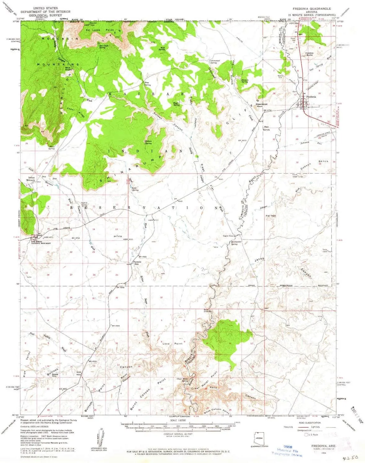
  • USGS topographic map of Fredonia, AZ, at 1:62500 scale. Heavier material. Waterproof. Tear-resistant. Foldable. Perfect for the outdoors.
  • Cities, towns, villages: Booze Crossing,Indian Moccasin,Kaibab,Nagles Crossing,Fredonia,Sixmile Village
  • Islands: Consult topo map preview for visible islands.
  • Parks and forests: Pipe Spring National Monument


USGS topographic map of Fredonia, Arizona, dated 1954, updated 1963.

Includes geographic coordinates (latitude and longitude), lines of elevation, bodies of water, roads, and more. This topo quad is suitable for recreational, outdoor uses, office applications, or wall map framing.

Printed on-demand by YellowMaps on the print material of your choice.

Shipping rolled from Minneapolis, MN, United States.

Product Number: USGS-5679170
Map Size: 20.7 inches high x 16.9 inches wide
Map Scale: 1:62500
Map Type: POD USGS Topographic Map
Map Series: HTMC
Map Version: Historical
Cell ID: 54384
Scan ID: 314601
Imprint Year: 1963
Woodland Tint: Yes
Visual Version Number: 1
Aerial Photo Year: 1953
Field Check Year: 1954
Datum: NAD27
Map Projection: Polyconic
Map published by United States Geological Survey
Keywords: Overedge
Map Language: English
Scanner Resolution: 600 dpi
Map Cell Name: Fredonia
Grid size: 15 X 15 Minute
Date on map: 1954
Geographical region: Arizona, United States
Northern map edge Latitude: 37°
Southern map edge Latitude: 36.75°
Western map edge Longitude: -112.75°
Eastern map edge Longitude: -112.5°

Surrounding map sheets (copy & paste the Product No. in the search bar):
North: USGS-5462565,USGS-5462163,USGS-5458331,USGS-5462567
East: USGS-5555820,USGS-5557236,USGS-5679190,USGS-5679188
South: USGS-5548118,USGS-5551864,USGS-5548116
West: USGS-5555022,USGS-5679162,USGS-5555850,USGS-5679192

You May Also Like

Fallout Tesla Science Magazine Retro-Style Metal Lunchbox | Reusable Storage Tin Container

$ 25.00

Save: $

Portable Outdoor Camp / Cooking Kit - Perfect for Camping, Backpacking, Hunting, Tailgating, Emergency Survival, Food Storage

$ 24.00

$ 35.00

Save: $

Beach Tent Pop Up Shade Canopy Sun Shelter UPF50  with 2 Stability Poles/Carry Bag/Ground Pegs/Sand Shovel/Windproof Ropes Portable Outdoor Family Sunshade for Beach Camping(Turquoise,10×10FT)
Beach Tent Pop Up Shade Canopy Sun Shelter UPF50 with 2 Stability Poles/Carry Bag/Ground Pegs/Sand Shovel/Windproof Ropes Portable Outdoor Family Sunshade for Beach Camping(Turquoise,10×10FT)

$ 42.00

$ 60.00

Save: $

MAGCOMSEN Men's Winter Coats Water Resistant Ski Snow Jacket Warm Fleece Jacket Parka Raincoats With Multi-Pockets

$ 48.00

$ 68.00

Save: $

Pocket Chainsaw High Hand Chain Saw 48inch Compact Portable Rope Saw Folding Pocket Chainsaw for Outdoor Camping Hunting Backpacking

$ 43.00

$ 61.00

Save: $

Stairs Mountain NH topo map, 1:24000 Scale, 7.5 X 7.5 Minute, Historical, 1987, Updated 1987, 26.8 x 21.6 in

$ 45.00

$ 64.00

Save: $

Rechargeable Headlamp 8 Pack, LED Headlight Flashlight Super Bright with 230° Wide Beam, Motion Sensor, 5 Modes Waterproof Head Lamp for Outdoor Hiking Running Camping

$ 28.00

$ 40.00

Save: $

GEMYSE Girl's Waterproof Ski Snow Jacket Fleece Windproof Winter Jacket with Hood

$ 49.00

$ 70.00

Save: $

Benson AZ topo map, 1:24000 Scale, 7.5 X 7.5 Minute, Historical, 1973, Updated 1976, 26.9 x 22 in

$ 45.00

$ 64.00

Save: $

Vintage New Zealand Railway Tours Map 1889

$ 50.00

Save: $

Cart
Cooking Essentials&Outdoor Tools|Foldable Shovels,Windproof Stoves&Headlamps
Your cart is currently empty.