Cooking Essentials&Outdoor Tools|Foldable Shovels,Windproof Stoves&Headlamps
Cooking Essentials&Outdoor Tools|Foldable Shovels,Windproof Stoves&Headlamps Cooking Essentials&Outdoor Tools|Foldable Shovels,Windproof Stoves&Headlamps
Home Navigation Gear Waterproof Hiking Map
Curley Peak CO topo map, 1:24000 Scale, 7.5 X 7.5 Minute, Historical, 1980, Updated 1983, 27.1 x 21.9 in

Curley Peak CO topo map, 1:24000 Scale, 7.5 X 7.5 Minute, Historical, 1980, Updated 1983, 27.1 x 21.9 in

$ 48.00

$ 69.00

Save: $

Color:
  • Polypropylene
  • Regular Paper
  • Tyvek
Unavailable
Please select combo product attributes
The combo subtotal is $,SAVE$

Product Details

  • Printed on Tyvek® (synthetic)
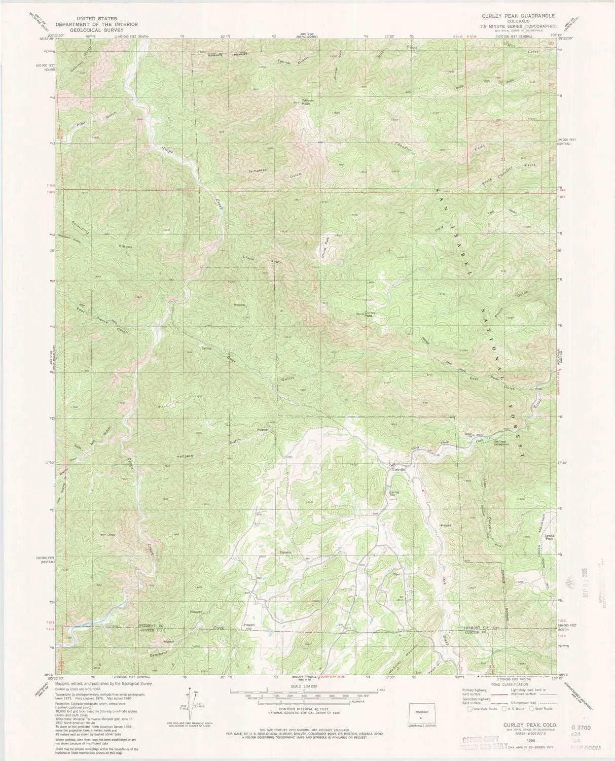
  • USGS topographic map of Curley Peak, CO, at 1:24000 scale. Lighter material. Waterproof. Tear-resistant. Foldable. Very durable. Perfect for backpacking and the outdoors.
  • Cities, towns, villages: Yorkville,Galena
  • Mountains: Curley Peak,Locke Mountain,Tanner Peak
  • Valleys: East Bear Gulch,Pine Gulch,Little Granite Gulch,Bear Gulch,Lion Canyon,Chute Gulch,East Pierce Gulch,East Mill Gulch,Granite Gulch,Ralph Gulch,Hale Gulch,Isinglass Gulch


USGS topographic map of Curley Peak, Colorado, dated 1980, updated 1983.

Includes geographic coordinates (latitude and longitude), lines of elevation, bodies of water, roads, and more. This topo quad is suitable for recreational, outdoor uses, office applications, or wall map framing.

Printed on-demand by YellowMaps on the print material of your choice.

Shipping rolled from Minneapolis, MN, United States.

Product Number: USGS-5348657
Map Size: 27.1 inches high x 21.9 inches wide
Map Scale: 1:24000
Map Type: POD USGS Topographic Map
Map Series: HTMC
Map Version: Historical
Cell ID: 11052
Scan ID: 400652
Imprint Year: 1983
Woodland Tint: Yes
Aerial Photo Year: 1975
Edit Year: 1980
Field Check Year: 1976
Datum: NAD27
Map Projection: Lambert Conformal Conic
Map published by United States Geological Survey
Map Language: English
Scanner Resolution: 508 dpi
Map Cell Name: Curley Peak
Grid size: 7.5 X 7.5 Minute
Date on map: 1980
Geographical region: Colorado, United States
Northern map edge Latitude: 38.375°
Southern map edge Latitude: 38.25°
Western map edge Longitude: -105.375°
Eastern map edge Longitude: -105.25°

Surrounding map sheets (copy & paste the Product No. in the search bar):
North: USGS-5355493,USGS-5355491,USGS-5355489,USGS-5355487
East: USGS-5355409,USGS-5355413,USGS-5355411,USGS-5355415
South: USGS-5353707,USGS-5353711,USGS-5353715,USGS-5353709,USGS-5353703
West: USGS-5351517,USGS-5351521,USGS-5351515,USGS-5351519

You May Also Like

Camping shovel Tactical Camping Shovel, 10-in-1 Multifunction Survival Tool, Portable Folding Spade,Compact Rescue Camping Shovel Multitool, for Self-Driving, Camping, Outdoor, Gardening and Emergency

$ 89.00

$ 197.00

Save: $

Burley SW ID topo map, 1:24000 Scale, 7.5 X 7.5 Minute, Historical, 1964, Updated 1978, 26.7 x 22 in

$ 34.00

$ 49.00

Save: $

8000mAH Explosion Proof Head Mounted headlamp Portable Rechargeable Industrial Mining lamp Flashlight Waterproof Safety Helmet Light Suitable for Hiking Outdoor Work

$ 48.00

$ 81.00

Save: $

Combat Iron Woobie Thermal Blanket | Military-Grade Camping Blanket, Poncho Liner | Insulated, Water-Resistant, Portable | American Flag

$ 31.00

$ 45.00

Save: $

Head Mounted Action Camera, 1080P Adjustable Angle Small Head Mounted Sports Camera, LED Headlamp Wearable Body Video Camera with Elastic Headband, Support 128GB for Outdoor Sports

$ 24.00

$ 35.00

Save: $

Paracord Rope, 328ft 4mm, 9 Strand Parachute Rope, Premium Nylon Type Lanyard with Cutting Groove for Camping,Clothsline,Hiking,Fishing and Survival

$ 16.00

$ 20.00

Save: $

Casa Grande MTS AZ topo map, 1:24000 Scale, 7.5 X 7.5 Minute, Historical, 1965, Updated 1966, 26.9 x 22.1 in

$ 45.00

$ 64.00

Save: $

Nitecore NU27 600 Lumens Running Camping Headlamp, USB-C Rechargeable with Warm, Neutral and Cool White Lights, Red Light, Including NitecoreS Sticker (Black)

$ 45.00

Save: $

National Geographic Scotland Wall Map - Classic - Laminated (30 x 36 in) (National Geographic Reference Map) Map – December 13, 2017

$ 20.00

$ 25.00

Save: $

Portable Camping Gas Stove Windproof Design Burner for Hiking Outdoor Cooking

$ 23.00

$ 29.00

Save: $

Cart
Cooking Essentials&Outdoor Tools|Foldable Shovels,Windproof Stoves&Headlamps
Your cart is currently empty.