Cooking Essentials&Outdoor Tools|Foldable Shovels,Windproof Stoves&Headlamps
Cooking Essentials&Outdoor Tools|Foldable Shovels,Windproof Stoves&Headlamps Cooking Essentials&Outdoor Tools|Foldable Shovels,Windproof Stoves&Headlamps
Home Navigation Gear Laminated Hiking Map
Classical Lands of the Mediterranean Wall Map - Published 1940 by National Geographic

Classical Lands of the Mediterranean Wall Map - Published 1940 by National Geographic

$ 59.95

$ 0.00

Save: $

Finish:
  • Paper
  • Laminated
  • Laminated with Hang Rails
  • Canvas
  • Canvas with Hang Rails
Unavailable
Please select combo product attributes
The combo subtotal is $,SAVE$

Product Details

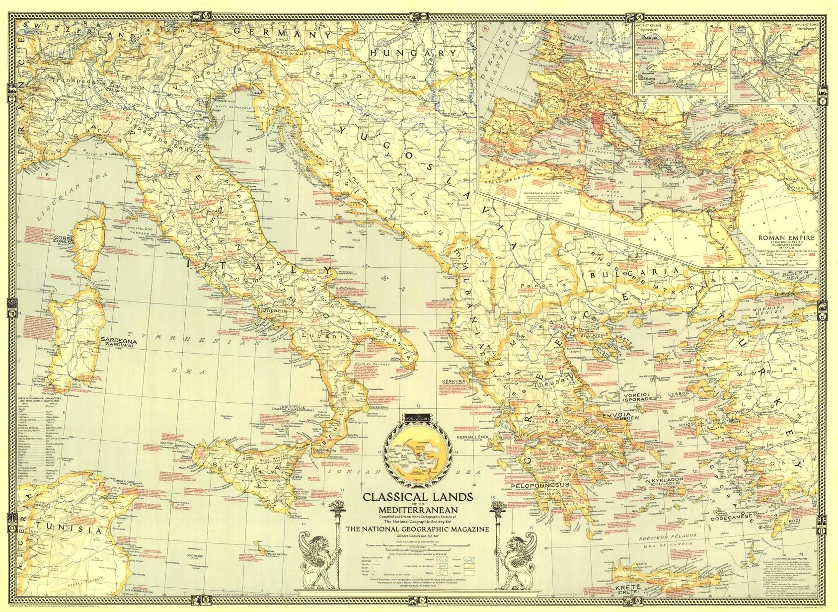
This map was published in March 1940 in an issue of National Geographic entirely devoted to the Classical Lands of the Mediterranean. An abundance of historical notes and detailed inset maps of ancient Athens, ancient Rome, and the Roman Empire illustrate the rich history of the region. This educational map also features an attractive border showing the twelve signs of the zodiac.

The map can be printed on heavyweight 160 gsm paper or laminated. The paper version is perfect for framing under glass, and the laminated version is exceptionally hard-wearing, as we use a true encapsulation of two pieces of 80-micron gloss laminate.

Alternatively, we can supply this map on 395 gsm HP Professional Matte Canvas using pigment-based inks, making it highly durable and fade-resistant. The exceptional clarity of the printing makes this map a stunning addition to any room, and its high quality means that it will provide years of enjoyment.

The easiest way to hang your canvas map is with wooden hang rollers attached to the top and bottom. The top roller has a hanging cord so that you can hang it from a hook on the wall. The hang rails are lacquered in a natural timber colour. 

Note: Please allow ten working days for delivery of hang-railed maps, as our framer needs to attach them.

Scale: 1:2,217,60

Published: 1940

Size: 893 x 652 mm

You May Also Like

Moab Classic Trails Map

$ 14.99

Save: $

Waypoint Geographic Glow in The Dark Star Map, Laminated Map of The Stars and Constellation, Durable Reference Map, Stunning Wall Art for Star Gazers, 33” x 23”

$ 20.00

$ 25.00

Save: $

4 Panel Solar Charger

$ 59.99

Save: $

LCP Velocity Parka Cinder Gray Size 4XL

$ 118.00

$ 295.00

Save: $

#4 Shell Beach/Hopedale

$ 31.00

$ 45.00

Save: $

SPOSULEI Mens Skiing Jackets with Hoode Snowboarding Waterproof Fleece Liner Coats Windproof Winter Raincoat Multi Pockets

$ 66.00

Save: $

Portable Stainless Steel Wood Burning Stove for Outdoor Hiking - Folding BBQ Kits for Picnics, Compact 2-3 People Camp Cooker

$ 30.00

$ 42.00

Save: $

CREATMO US Men's Packable Waterproof Running Rain Coats Reflective Cycling Jacket Windbreaker With Removable Hood

$ 32.00

$ 46.00

Save: $

US Scratch Off Map Poster with Photos Underneath of all 50 States Scratch Off Map in the USA Map of Travels Poster 32 x 24 Inches

$ 27.00

Save: $

Children's Political Map of South America 668 x 905mm

$ 59.95

Save: $

Cart
Cooking Essentials&Outdoor Tools|Foldable Shovels,Windproof Stoves&Headlamps
Your cart is currently empty.