- Printed on Polypropylene (plastic)
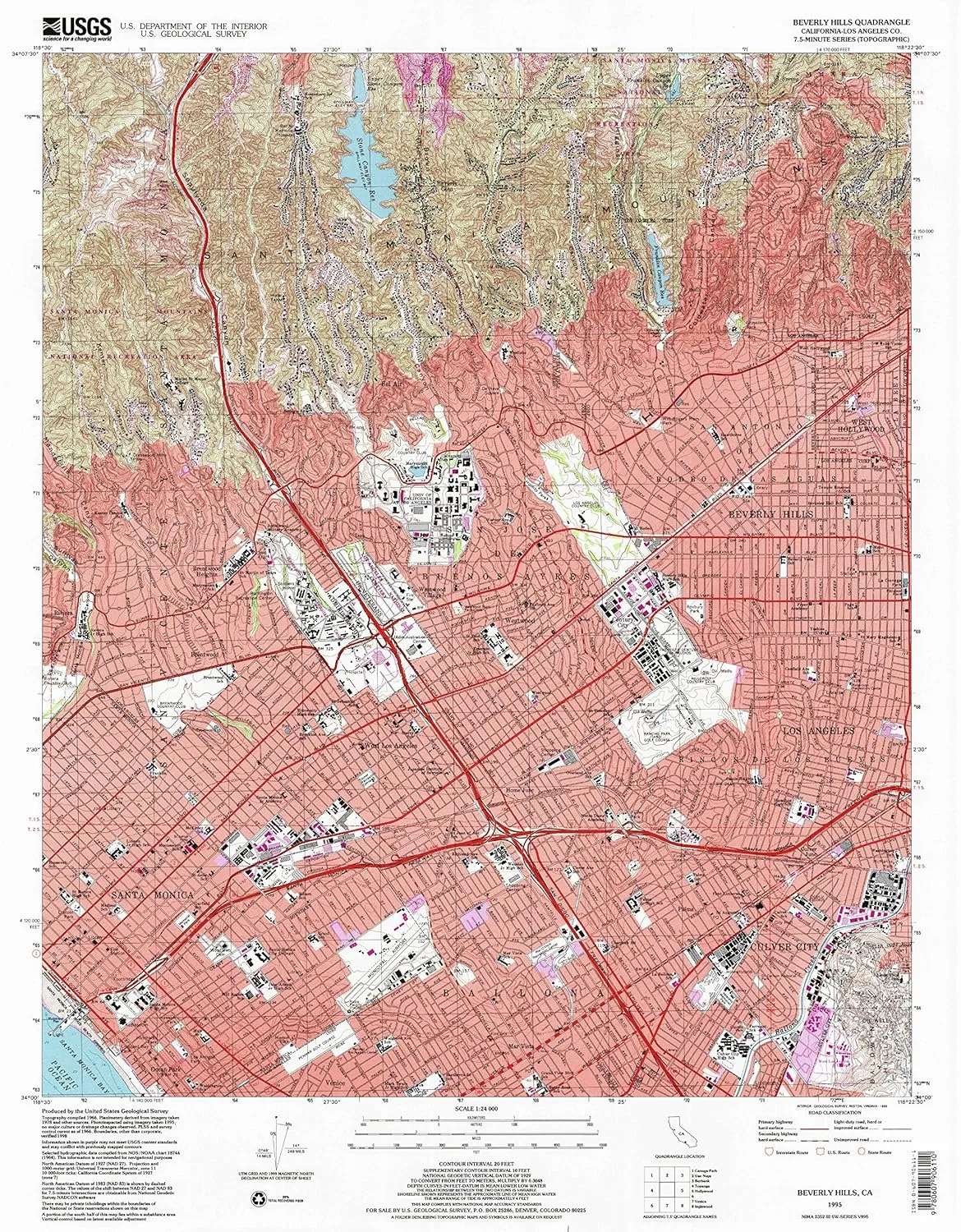
- USGS topographic map of Beverly Hills, CA, at 1:24000 scale. Heavier material. Waterproof. Tear-resistant. Foldable. Perfect for the outdoors.
- Cities, towns, villages: West Los Angeles,Westgate,Brentwood,Culver Junction,Palms,Bel Air,Century City,Beverly Hills,Brentwood Heights,Mar Vista Houses,Beverly Glen,Ocean Park,Brentwood Park,Mar Vista,Westwood,Home Junction,Westwood Village,Santa Monica,Sawtelle,Westgate Heights,Culver City,Trousdale Estates
- Islands: Consult topo map preview for visible islands.
- Parks and forests: Douglas Park,Mathias Botanical Garden,Murphy Sculpture Garden,Blair Hills Park,Media Park,Stoner Recreation Center,Laurel Canyon Park,Culver City Park,Jackie Robinson Stadium,Corsair Stadium,West Hollywood Park,Oakhurst Park,Dickson Plaza,Clover Park,Doctor Carlson Memorial Park,Roxbury Park,Robertson Playground,Ozone Park,Lincoln Park,Greystone Park,Barrington Recreation Center,Penmar Recreation Center,Electric Fountain,Crestwood Hills Park,Drake Stadium
USGS topographic map of Beverly Hills, California, dated 1995, updated 1999.
Includes geographic coordinates (latitude and longitude), lines of elevation, bodies of water, roads, and more. This topo quad is suitable for recreational, outdoor uses, office applications, or wall map framing.
Printed on-demand by YellowMaps on the print material of your choice.
Shipping rolled from Minneapolis, MN, United States.
Product Number: USGS-5508381
Map Size: 26.9 inches high x 21.5 inches wide
Map Scale: 1:24000
Map Type: POD USGS Topographic Map
Map Series: HTMC
Map Version: Historical
Cell ID: 3588
Scan ID: 100133
Imprint Year: 1999
Woodland Tint: Yes
Photo Inspection Year: 1995
Aerial Photo Year: 1978
Datum: NAD27
Map Projection: Universal Transverse Mercator
Map published by United States Geological Survey
Map Language: English
Scanner Resolution: 600 dpi
Map Cell Name: Beverly Hills
Grid size: 7.5 X 7.5 Minute
Date on map: 1995
Geographical region: California, United States
Northern map edge Latitude: 34.125°
Southern map edge Latitude: 34°
Western map edge Longitude: -118.5°
Eastern map edge Longitude: -118.375°
Surrounding map sheets (copy & paste the Product No. in the search bar):
North: USGS-5525335,USGS-5525339,USGS-5525341,USGS-5525337,USGS-5525343
East: USGS-5515537,USGS-5515533,USGS-5515535,USGS-5515539,USGS-5515531
South: USGS-5525365,USGS-5503961,USGS-5503959,USGS-5658111,USGS-5658105
West: USGS-5524737,USGS-5658067,USGS-5658065,USGS-5524729,USGS-5524727


")


