- Printed on Tyvek® (synthetic)
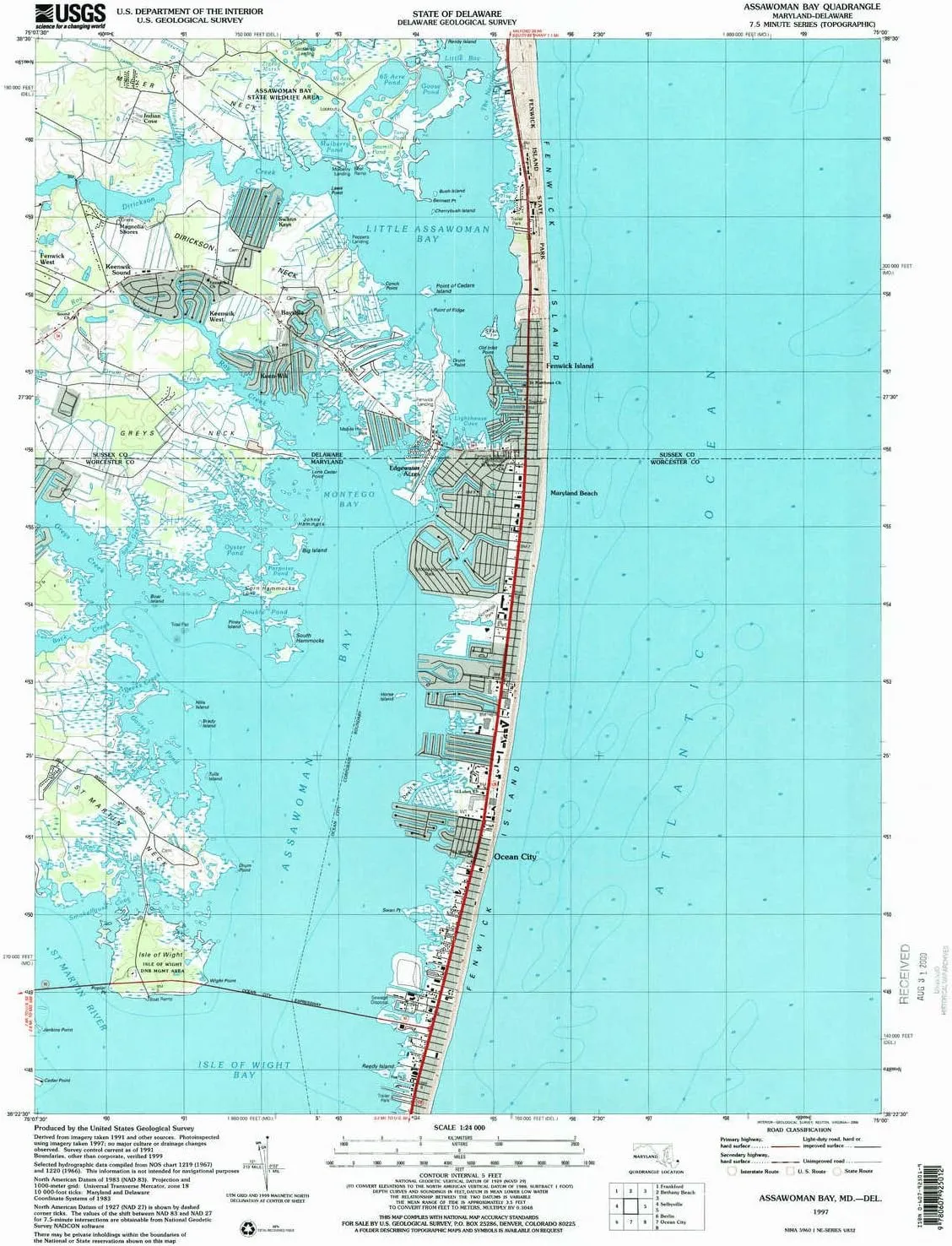
- USGS topographic map of Assawoman Bay, MD, at 1:24000 scale. Lighter material. Waterproof. Tear-resistant. Foldable. Very durable. Perfect for backpacking and the outdoors.
- Cities, towns, villages: Oak Acres,Fenwick,Teaberry Woods,Indian Cove,Keenwik Sound,Keenwik West,Kings Grant,Fenwick Landing,The Shoals,Seaside Villas,Hidden Harbor,Sassafras Landing,Swann Keys,Bayville,Sea Dunes,Keen-Wik,Mulberry Landing,Edgewater Acres,Magnolia Shores,Bayside Keys,Caine Keys,Peppers Landing,Fenwick West,Caine Harbor Mile,Fenwick Island,Seatowne,Montego Bay,The Narrows,Ocean Bay City,Queens Quest,Fenwick Estates,Warrens Park,Cainwoods
- Mountains: High elevation topographical features like high summits and peaks.
- Valleys: Low elevation topographic features such as flatlands, river valleys, and canyons.
USGS topographic map of Assawoman Bay, Maryland, dated 1997, updated 2000.
Includes geographic coordinates (latitude and longitude), lines of elevation, bodies of water, roads, and more. This topo quad is suitable for recreational, outdoor uses, office applications, or wall map framing.
Printed on-demand by YellowMaps on the print material of your choice.
Shipping rolled from Minneapolis, MN, United States.
Product Number: USGS-5365668
Map Size: 26.8 inches high x 22 inches wide
Map Scale: 1:24000
Map Type: POD USGS Topographic Map
Map Series: HTMC
Map Version: Historical
Cell ID: 1717
Scan ID: 256016
Imprint Year: 2000
Woodland Tint: Yes
Photo Inspection Year: 1997
Aerial Photo Year: 1991
Datum: NAD83
Map Projection: Universal Transverse Mercator
Map published by United States Geological Survey
Map Language: English
Scanner Resolution: 600 dpi
Map Cell Name: Assawoman Bay
Grid size: 7.5 X 7.5 Minute
Date on map: 1997
Geographical region: Maryland, United States
Northern map edge Latitude: 38.5°
Southern map edge Latitude: 38.375°
Western map edge Longitude: -75.125°
Eastern map edge Longitude: -75°
Surrounding map sheets (copy & paste the Product No. in the search bar):
North: USGS-5390272,USGS-5389890,USGS-5389900,USGS-5389894,USGS-5389898
East:
South: USGS-5367772,USGS-5366910,USGS-5366904,USGS-5366908,USGS-5366912
West: USGS-5390288,USGS-5390196,USGS-5367224,USGS-5390198,USGS-5367222


